Mount Kipipiri is a dormant volcano in the Wanjohi Valley, near the Aberdare Range, on the Kinangop Plateau. It’s about 20 miles (32 kilometers) northeast of Lake Naivasha, which can be seen from the top. Colobus and Sykes monkeys, elephants and buffalo, as well as a plethora of birds, may all be found in the area. In the Gikuyu language, the mountain’s name means “butterfly,” a reference to its profile from afar.
The Aberdare National Park includes the Mount Kipipiri Forest Reserve. About 13 elephants were predicted to live in the 43 square kilometer (17 square mile) forest reserve in 2005.
Long talks on the alignment of a wildlife corridor between Kipipiri and the main Aberdare park were completed in June 2009, with plans to fence the corridor. [4] At the spots where highways intersect the corridor, grids of rolling bars with spaces between them replace the barrier, producing an obstruction that motorists may overcome but animals will not. This keeps animals out of farmers’ fields, notably elephants. [5]
Mt Kipipiri stands big in the imaginations of those who are interested in history. Wanjohi Valley, under its shadow, was a hotspot of hedonism among European settlers from the 1920s through the 1940s. Several novels have been published about the colorful people of Happy Valley (its more renowned moniker) during that time period.
Back then, the famous joke “Are you married or do you live in Kenya?” was inspired by their active lifestyle.
After Kenya attained independence, landless people were placed on the lower slopes of Mt Kipipiri, while the top portions were proclaimed a forest reserve under the supervision of the Kenya Forest Service (KFS). An electric fence was built around it, conserving a large portion of the area’s native woodlands for future generations.
Mt Kipipiri has recently piqued people’s curiosity, either because it’s new area for hikers, or because of the appeal of Happy Valley’s raunchy tales. It’s a wonderful area to go hiking and camping for whatever reason.
Hiking Kipipiri: Route Information
Hiking up Mt Kipipiri usually begins at the Geta Forest Station on the mountain’s southeastern edge.
After a gradual rise from Geta at 2500m asl to 3345m asl at its top, and then back down to 2430m, the trip to Miharati on the northern end takes 8-9 hours.
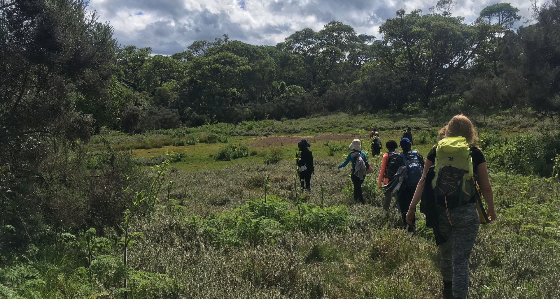
Tractor tracks may be found along the trail’s earliest parts, which are used by tractors harvesting trees from plantations on the lower slopes. Animal routes on broad meadows with the odd river crossings eventually take their place.
The woodland transitions from exotic to indigenous trees with lots of undergrowth around two hours into the trip. From various vantage points, the meadows develop into enormous beds of colorful wildflowers, with vistas of the valleys below populated with houses, fences, and farms.
In certain areas, the trail disappears behind the cover of the forest, only to reappearance later. You’ll also come across local game that happens to be cattle (mainly bulls) that have been driven into the abundant forest by the neighboring town and allowed to fend for themselves for years until they are old enough to be slaughtered. The owners appear to visit the woodland on a regular basis to provide salt to the animals and offer immunizations.
A brief stop halfway to the peak at a rocky outcropping provides magnificent views over the lowlands to the east and south, as well as the Aberdares Range’s slopes. The last stretch to the top is undulating, with occasional dives into little valleys and easy rises in between.
As you approach closer, you’ll come across some marshy areas filled with clumps of tussock grass that serve as ideal stepping stones to escape the squishy ground. Once you’ve gotten over these stumbling blocks, you’ll notice Mt Kipipiri’s peak, which is a massive rock. It’s a short but steep hike to the top, but it’s well worth it for the spectacular, previously unknown views to the north and west of the mountain. To the north, the sparkling Lake Ol Bolosat can be seen, while to the west, Lake Naivasha can be viewed.
After over the Electric fence, the descent is a brief steep fall via some wooded parts, ultimately breaking out into fields. Miharati is a short walk from the woodland border on the Njabini – Ol Kalou tarmac route.
If you parked your car in Geta, you may take public transportation back to Nairobi or to Ndunyu Njeru from Miharati.
Caution: Bring rain gear and thick clothing, as the area gets a lot of rain and temperatures in the single digits at this height.
Getting there
Take Ndunyu Njeru Matatus from Old Nation House matatu stage if taking public transportation to Mt Kipipiri. You may take local taxis or boda boda (taxi motorbikes) to Geta, which is around 12 kilometers distant, from Ndunyu Njeru.
If coming from Nairobi, use the upper escarpment’s Nakuru Road for about 60 kilometers to a point known as the flyover. Proceed over the flyover, then turn left at the next junction and drive for about 24 kilometers to Njabini town.
If you parked your car in Geta, you may take public transportation back to Nairobi or to Ndunyu Njeru from Miharati.
Caution: Bring rain gear and thick clothing, as the area gets a lot of rain and temperatures in the single digits at this height.
How to Get There
Take Ndunyu Njeru Matatus from Old Nation House matatu stage if taking public transportation to Mt Kipipiri. You may take local taxis or boda boda (taxi motorbikes) to Geta, which is around 12 kilometers distant, from Ndunyu Njeru.
If coming from Nairobi, use the upper escarpment’s Nakuru Road for about 60 kilometers to a point known as the flyover. Proceed over the flyover, then turn left at the next junction and drive for about 24 kilometers to Njabini town.
Drive to Engineer on Ol Kalou Road, then turn right to Ndunyu Njeru Junction, where you’ll turn right into a murram road. Geta will be another 12 kilometers up this difficult road from the market, which is only a kilometer off the road.
Despite the fact that the distance between Nairobi and Geta is just approximately 130 kilometers, the journey takes at least three hours owing to the difficult part.
Camping at Kipipiri Mountain
Because of the 3-hour flight from Nairobi to Geta and the 9-hour climb, you may need to camp overnight. The KFS rangers can provide you with information about the closest campsites in the region.