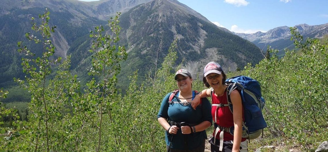
Choosing the right hiking shirts for climbing Kilimanjaro, Mount Kenya, and Mount Meru is about balancing moisture management, comfort, and protection. Climbing these mountains in East Africa, including the Rwenzori mountains in Uganda and the active Old Doinyo Lengai volcano, is a remarkable adventure that requires meticulous preparation, particularly when it comes to selecting the right hiking shirts. These iconic African peaks present climbers with a diverse range of temperatures and weather conditions, from the warm, humid rainforests at the base to the cold, windy summit zones. Your hiking shirt, often referred to as a base layer, is the foundation of your clothing system, playing a critical role in keeping you dry, warm, and protected throughout the trek. This comprehensive guide will explore the key considerations for choosing hiking shirts for these climbs, including materials, types, fit, weight, and recommended products, ensuring you are well-equipped for success. Research suggests hiking shirts should be made from synthetic fabrics or merino wool for moisture-wicking and warmth, avoiding cotton due to its slow-drying nature. It seems likely that a mix of short-sleeve and long-sleeve shirts is best, with long sleeves preferred for sun and wind protection at higher altitudes. The evidence leans toward lightweight base layers for versatility across varying temperatures, with snug fits for effective moisture management. Related: The Recommended Base Layers & Hiking Shirts for Climbing Kilimanjaro Understanding the Climatic Challenges Before delving into the specifics, it’s important to understand the climatic challenges posed by Kilimanjaro, Mount Kenya, and Mount Meru. Kilimanjaro, standing at 19,341 feet, takes you through five ecological zones, from tropical rainforests to arctic summit conditions, with temperatures ranging from 80°F at the base to below 20°F at the summit. Mount Kenya, at 17,021 feet, offers similar diversity, while Mount Meru, at 14,980 feet, is slightly less extreme but
Choosing the right hiking shirts for climbing Kilimanjaro, Mount Kenya, and Mount Meru is about balancing moisture management, comfort, and protection. Climbing these mountains in East Africa, including the Rwenzori mountains in Uganda and the active Old Doinyo Lengai volcano, is a remarkable adventure that requires meticulous preparation, particularly when it comes to selecting the
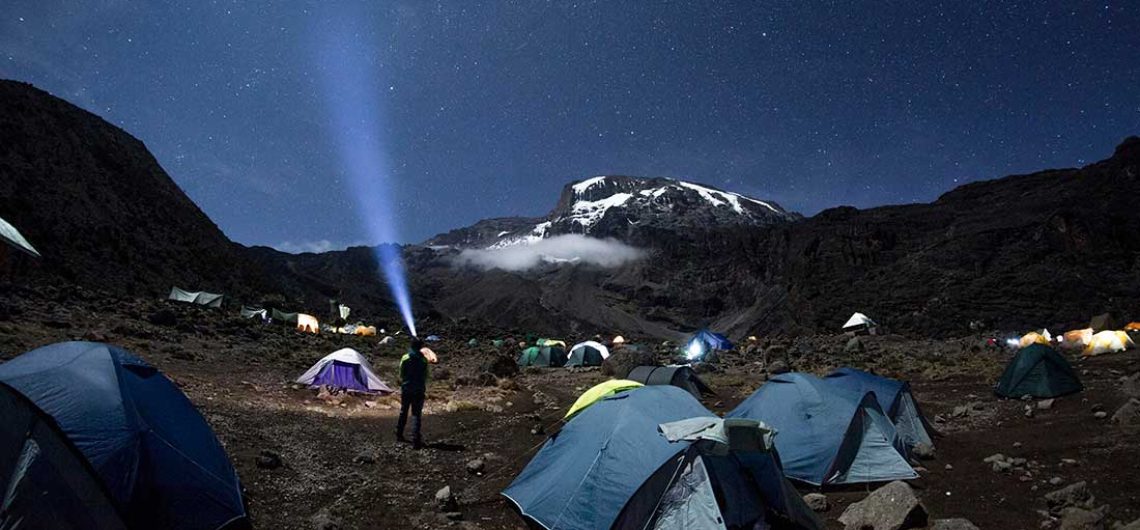
My watch buzzes just before midnight, snapping me into focus. I fumble into my gear, ruthlessly culling half the contents of my pack—weight is the enemy now, not lack of supplies. The rest gets shoved haphazardly into my duffel. My tentmate, Bob, a 70-year-old with a lean frame and fierce determination, sleeps soundly. His two daughters, cheering him on from afar, would be proud of his grit, but exhaustion has won tonight. The summit isn’t his today. I stumble out of the tent, legs thrusting me forward, arms pushing me up from the ground. The effort leaves me gasping. Above, a sky thick with alien constellations glitters coldly. I head to the mess tent, one of the first to arrive, where gas lamps offer feeble warmth against the sharp, frosty dark. Top 4 tips to Stargaze and photograph the stars of Mount Kilimanjaro's night sky The crew, usually vibrant, move sluggishly, their energy dimmed. I sit silently, mentally tallying my odds: 75% chance of summiting, up from 20% on day one. I’ve slept decently, hiked strongly, but 1,300 meters of ascent looms—roughly a Ben Nevis, with half the oxygen. Or like climbing the 15 flights to the top floor of the city hospital 26 times, where I’d paced during my father’s final days. This will demand everything. Heidi, my reason for being here, arrives looking worn. Her invitation pulled me from a grey haze into a world of longing and clarity, though she doesn’t know it. Altitude’s been rough on her, but she’s holding up. Others trickle in. We nibble biscuits, sip tea, and absorb the briefing. “One team, one goal,” they say, but the tone is grave—stay behind the guides, follow orders. I miss coffee, then feel a pang of guilt. Porters, wiry locals paid a pittance, haul water,
My watch buzzes just before midnight, snapping me into focus. I fumble into my gear, ruthlessly culling half the contents of my pack—weight is the enemy now, not lack of supplies. The rest gets shoved haphazardly into my duffel. My tentmate, Bob, a 70-year-old with a lean frame and fierce determination, sleeps soundly. His two
Hiking in Tanzania is just the same as any other top hiking destination in the world because we have record-smashing mountains here. Mount Kilimanjaro, for example, is the highest free-standing mountain in the world, is snow-capped, needs a great deal of preparation, stands at 5,895m above sea level, just a few meters shy of 6000m high, which makes it the highest point in the continent of Africa. Not only that, but to complete the seven summit fetes, Kilimanjaro is a must-have on your bucket list. That being said, this should not take away from the fact that there are other great mountains and trails to hike in the country. See, Kilimanjaro takes most of the limelight, but there are other great highlands and mountains that can give you a satisfying hike, and you can find the full list of the hills, highlands and mountains here. Now, this article I am writing is purposely to enlighten you on the overall experience and expectations when hiking in Tanzania. Tanzania, nestled in East Africa, is a haven for hiking enthusiasts, offering a tapestry of landscapes from the snow-capped summit of Mount Kilimanjaro to the verdant trails of Udzungwa Mountains National Park. This comprehensive guide, informed by extensive research, aims to equip hikers with all the necessary details for a safe and enriching adventure, covering top destinations, preparation, weather considerations, safety, cultural awareness, and practical logistics. Contact us here if you plan to hike in Tanzania Where can you hike in Tanzania? Well, Tanzania is blessed with many hiking destinations, but the Northern part of the country is one you should not miss because all the highest mountains and highlands are concentrated in this part. The moment you travel to the northern circuit of Tanzania, you will come across rolling hills, valleys and mountains
Hiking in Tanzania is just the same as any other top hiking destination in the world because we have record-smashing mountains here. Mount Kilimanjaro, for example, is the highest free-standing mountain in the world, is snow-capped, needs a great deal of preparation, stands at 5,895m above sea level, just a few meters shy of 6000m
Before we list our top luxury hotels list for Arusha, thought we should just let you know that, Arusha, the bustling urban gateway to Tanzania's northern safari circuits, is not just a point of departure but a destination in its own right, especially when it comes to luxury accommodations. Encircled by the dramatic landscapes that lead to Mount Kilimanjaro, the Serengeti, and the Ngorongoro Crater, Arusha offers a unique blend of adventure and indulgence. Here, luxury isn't merely about opulence but about experiencing Tanzania's natural and cultural richness in comfort. Imagine waking up to the soft light of dawn painting the peaks of Mount Meru, or the sound of exotic birds greeting the day from the lush gardens of your lodge. These hotels and lodges in Arusha are not just places to rest your head; they are sanctuaries designed to elevate your entire Tanzanian experience. Each property has been meticulously chosen for its ability to offer not just a stay but an immersion into luxury that resonates with the spirit of East Africa. The architecture often reflects a harmonious blend of traditional African aesthetics with modern comforts, providing an ambiance where you feel connected to the land while enveloped in luxury. From sprawling estates with views of coffee plantations to intimate lodges nestled in the shadow of mountains, these establishments cater to those who seek the extraordinary. Here, dining transcends the ordinary; it's an exploration of flavors where local ingredients meet international culinary arts, often under the stars with the backdrop of Africa's vast skies. Wellness is not just a concept but a practice, with spas that use indigenous treatments to rejuvenate both body and soul. For those interested in more than just relaxation, these hotels often serve as gateways to bespoke adventures, whether it's a private safari, a trek
Before we list our top luxury hotels list for Arusha, thought we should just let you know that, Arusha, the bustling urban gateway to Tanzania’s northern safari circuits, is not just a point of departure but a destination in its own right, especially when it comes to luxury accommodations. Encircled by the dramatic landscapes that
When hiking in Tanzania, where you stay plays a crucial role in many things, logistically like nearness to important facilities like banks, and restaurants, shopping and even hiring hiking equipment. Tucked away in the heart of Eastern Africa, Tanzania beckons adventurers with its rich tapestry of natural wonders. From the awe-inspiring summit of Mount Kilimanjaro to the vast, untamed plains of the Serengeti, this country is a paradise for those who love to hike. However, choosing the right base for your Tanzanian adventures can make all the difference in your experience. Moshi is an amazing town to stay for hiking not just because it is home to the highest mountain in Africa but also the nearness to many hiking landforms but after much consideration, we picked Arusha as the ultimate winner. Let's dive into why Arusha stands as the quintessential hub for hikers and explorers alike, and where you should consider staying to make the most of your journey. Arusha, nestled at the foot of Mount Meru and a stone's throw from the world-famous Kilimanjaro, has become the de facto base camp for those embarking on Tanzania's numerous outdoor escapades. I've spent two adventurous months here, and from my experience, there's no better place to set up your temporary home. The city is vibrant yet manageable, with a mix of local and international flavours that cater to every palate and pocket. Why Arusha? Firstly, Arusha’s strategic location is unbeatable. It's not just about being close to Kilimanjaro; Arusha is also the gateway to some of Tanzania's most renowned national parks like Tarangire, Lake Manyara, and the Ngorongoro Crater. After a day or week of hiking, you can easily transition into a safari experience, making Arusha the perfect logistical hub. The city itself is a blend of the traditional and modern,
When hiking in Tanzania, where you stay plays a crucial role in many things, logistically like nearness to important facilities like banks, and restaurants, shopping and even hiring hiking equipment. Tucked away in the heart of Eastern Africa, Tanzania beckons adventurers with its rich tapestry of natural wonders. From the awe-inspiring summit of Mount Kilimanjaro