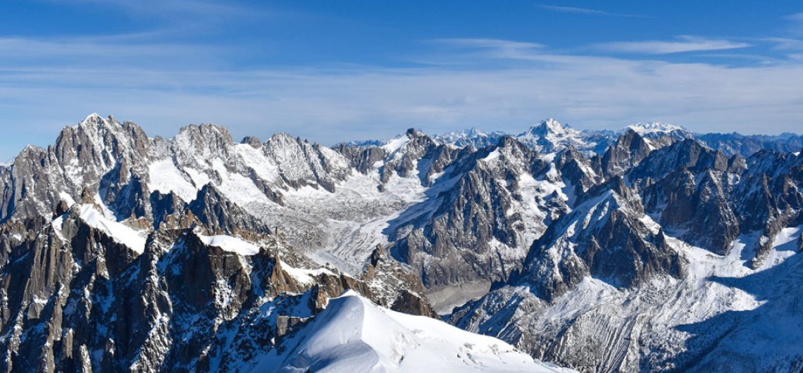
Most of the highest mountains in France have a base in the Alps. France, the third-largest country in Europe, is characterized by several elevated mountain ranges, the summits of which receive significant snowfall. In the French Alps, a sequence of large and well-known mountains can be found. Ranging from Mont Blanc in the northwest and finishing with the Marguareis in the southwest, the following is a list of the highest mountains in France. France shares the summit of Mont Blanc with Italy, and the mountain is, in turn, the world’s third most prominent peak. Mont Blanc (Monte Bianco) means “White Mountain,” and at 4,810 m, it is the highest in the Alps and Western Europe. It was first climbed by Jacques Balmat and Michel Paccard in 1786. It is very popular with mountaineers, as there are many routes to the summit. In addition, the Mont Blanc massif is a popular area for ski mountaineering and hiking. The Mont Blanc Tunnel links the Chamonix valley in France with the Aosta Valley in Italy and is a major transalpine transport route. On the French side, the tunnel’s access point is in the Chamonix valley, linking directly to the autoroute system. Following Mont Blanc in height is the Monte Rosa, whose summit is in Switzerland. At 4,634 m high, the Dufourspitze is the highest point in Switzerland and the second highest in the Alps. This too is a popular mountaineering destination. On the north face is the Swiss Monte Rosa Hut, the highest (2,795 m) hut in the Alps. The present building was opened in 2009, replacing the old hut built in 1939.
1. Mont Blanc – 4,809m
Guided climbs for Mont Blanc start from Chamonix, which is easily accessible from Geneva airport. The climb can be done in a short period if the weather and the parties’ fitness are good. Normally, people opt for a three-day program which allows two nights to be spent in mountain refuges. The valley to summit normally takes around 8 to 10 hours. This allows time to relax at the refuges and to get fitter and acclimatized for the ascent. It also provides a suitable weather window for the summit attempt. Also, chances of a sunrise/sunset ascent are greatly increased.
Mont Blanc, the name itself suggests greatness and it lived up to the expectation. Being the tallest mountain in France, Mont Blanc is a climber’s paradise. It offers a range of routes varying in difficulty and commitment. Mont Blanc rises above all the other peaks in the region and is clearly visible from a great distance. Each day, the mountain presents a different challenge and experience. There is a special feeling to be had when you are on the highest mountain in western Europe.
2. Mont Maudit – 4,465m
The mountain is very dangerous with frequent rockfall and avalanches. The snow couloir which leads to the summit is especially prone to both hazards. There have been fatalities on both the normal route and on the Peuterey ridge from avalanches. The most prominent was the 1950 accident where 4 groups totaling 27 climbers were caught in bad weather and became disoriented. They all fell over a cliff with the loss of 9 lives.
Mont Maudit is a mountain in the Mont Blanc massif in the French Alps. It is linked to the Tour Ronde on the west and to Mont Blanc on the east. The normal route to the summit is from the Col du Mont Maudit at 4345m. The mountain is usually climbed as a 2-day trip from the Cosmiques Hut using the Midi-Plan traverse to access the Col du Mont Maudit. The mountain was first climbed by Moriz Norman-Neruda and A. W. Moore with the guides Johann Jaun and Josef-Marie Perrod on 27 July 1878.
3. Dôme du Goûter – 4,304m
Located in the center of the Mont-Blanc massif, the Dome du Gouter is sometimes confused with the tourist destination Mont Blanc (4,809 meters, 15,774 ft). While less well known, Mont Blanc’s summit is 600 meters south of the Dome. Barometer measurements have been made on the summit of the dome. It is the highest point in Europe for which a topographic map has been made. Dôme du Goûter itself is only the 3rd highest peak in the Mont Blanc massif, but is the 2nd most climbed peak of the range. The normal route summiting starts at the Mont Blanc Tramway station, in the hamlet of Le Mont Lachat, near Saint-Gervais-les-Bains and goes up the Arete du Gouter. The Dome du Gouter has a unique view of Mont Blanc. Its south face is barely steep and is covered in ice, which is the largest and only glacier on Mont Blanc. Unfortunately, because the Glacier d’ Dome periodically slides, the mountain hut Refuge de Gouter, located to the east of the Dome and on the Arete du Gouter, is being dragged into the crevasse. This has led the French Alpine club to make plans for a new hut. Due to its mild grade and relatively short climbing distance, ascent to the Dome is good preparation for those wishing to climb Mont Blanc. On a clear day, the summit provides an excellent view of Refuge de Tete Rousse, Mont Blanc, and the Chamonix valley.
4. Mont Blanc du Tacul – 4,248m
Mont Blanc du Tacul is a 4,248-meter high mountain in the Mont Blanc massif in the French Alps. The mountain is one of the three summits of Mont Blanc, the other two being Mont Blanc du Courmayeur (4,748 m) and the Grand Pilier d’Angle (4,358 m). The mountain is covered with glacial ice and ascended on its west side by the Aiguille du Midi, which is a 3,842m peak. The ‘Three Monts Route’ is a great snow and ice climb which takes you from the summit of the Aiguille du Midi to the foot of Mont Maudit. From there, you go up Mont Maudit and onto the Col du Mont Maudit at about 4,250m. It takes around 3-6 hours to reach the col, and bivouac facilities can be reached by an hour’s walk down the other side of the col. This is a wise move as there is a significant risk of rockfall on the face, particularly in the afternoon. There are still many large seracs that threaten the col.
5. Grandes Jorasses – 4,208m
On the south side of the range, we have the Triolet Glacier and the refuge de Couvercle. Here, there are mixed routes of a modern nature and the classic Chere Couloir on the Aiguille d’Argentiere. The North face of the Aiguille de Talefre offers long mixed routes of a lower altitude, often circumventing savage serac barriers.
Grandes Jorasses is the highest peak in the Aiguille de Planparcro North face. There lies the classic Nordwand (ED 2 5c 2100m), which until now remained the only route on the mountain. The huge west face is split by a spur. The left side is called A point Jorasses Occidentale (pointe Whymper) at 3843m and the right side is called Grandes Jorasses occidentale 3786m (pointe Croz). Here, there are mixed routes ranging from AD to 800m TD with the great potential of harder modern lines. On the A pointe, there is the normal route from the A pointe with an ascent of some snow, ice, and mixed at AD II 3 400m. This is popular with alpinists based in the huts around the Mont Dolent sector. The West and Aiguille de Leschaux Glaciers offer an excellent training ground for would-be alpinists hoping to step up onto the steeper mixed routes of the Mallory and Croz.
6. Aiguille Verte – 4,122m
The Aiguille Verte is one of the most famous peaks in the Mont Blanc massif. It was first climbed in 1865 by Edward Whymper. The mountain is very steep and has many couloirs, the majority of which lead directly to the glacier. Because of its steep northern side, it is very prone to avalanches. Some scientists have argued that the mountain’s glacier has shrunk in recent years because of global warming. The conventional route is the Whymper route, named after the first climber to reach the summit. The route can be seen from Chamonix and from the Albert Premier Refuge and is the easiest way to the summit. At sunrise and sunset, the Aiguille Verte is a spectacular sight to see because of its various couloirs turning different shades of snow and ice. It is a very popular mountain for climbers because of its variety of routes, although it is very dangerous.
7. Barre des Écrins – 4,102m
Barre des Écrins has many more routes of all difficulties and lengths. Some of the best routes include Fissure d’Ailefroide, NE face Dibona Arete, SW face + traverse. All of these routes are equally isolated and give you good access to a solitary mountain and much deserved satisfaction.
The normal route, the NW ridge, offers a fantastic 1200m 50 degrees snow and ice climb with a short 5.4/AD rock step near the top. This route is considered the best in the Dauphiné, with good hut access at the Pré de Madame Carle car park, 3 hours walk to the Glacier Blanc Refuge. The route ascends the Glacier Noir and crosses the Col des Écrins to reach the Glacier des Agneaux, later climbing to the Col des Avalanches. The Glacier de la Barre is ascended to the foot of the NW ridge where the refuge is situated. This climb is a beautiful and varied climb, the snow and ice lower down and the rock step can even all be done in one day. An early start is needed and care should be taken as there are objective dangers from surrounding parties kicking down ice and rocks. Any ascent in late season should take note of the big crevasses and lack of snow on the glacier.
Barre des Écrins is remarkable for its difficult towers and black cliffs. You can easily recognize it by its glacier, which plateaus on the lower slopes of the mountain. It is surrounded by other smaller glaciers as well as beautiful rock faces. This is a great mountain for those interested in engaging climbs, somewhat isolated from the easier and more popular 4000m peaks in France. It is far from the main road and the mountain huts are a long walk away, therefore it is quieter than the rest of the Dauphiné 4000m peaks and has a more serious mountaineering atmosphere.
8. Aiguille de Bionnassay – 4,052m
Aiguille de Bionnassay is a majestic mountain peak located in the Mont Blanc massif of the French Alps. Standing at an impressive elevation of 4,052 meters (13,294 feet), it offers a striking pyramid-shaped silhouette against the alpine skyline. Situated between the Mont Blanc Massif and the Dômes de Miage, Aiguille de Bionnassay is renowned for its challenging and technical climbing routes, attracting experienced mountaineers from around the world.
The mountain is composed primarily of gneiss and schist, contributing to its rugged and imposing appearance. Aiguille de Bionnassay is flanked by glaciers on both its northern and southern faces, including the Glacier de Bionnassay and Glacier de Tré-la-Tête, adding to its scenic allure and providing thrilling opportunities for glacier trekking and ice climbing.
Climbing Aiguille de Bionnassay presents a formidable challenge, requiring climbers to navigate steep rock faces, crevassed glaciers, and unpredictable weather conditions. Popular routes to the summit include the classic traverse from the Durier Hut or the ascent via the Aiguille de Bionnassay ridge. Regardless of the chosen route, climbers are rewarded with awe-inspiring panoramic views of the surrounding alpine landscape, including the towering peaks of Mont Blanc and the Aiguille du Midi.
9. Dôme de Neige des Écrins – 4,015m
Dôme de Neige des Écrins is a prominent mountain peak located in the Écrins National Park in the French Alps. Standing at an elevation of 4,015 meters (13,171 feet), it is the highest point in the Massif des Écrins and the second-highest peak in the entire French Alps. Known for its stunning glacial features and alpine beauty, Dôme de Neige des Écrins offers a rewarding challenge for mountaineers and outdoor enthusiasts.
The mountain is characterized by its expansive snowfields and glaciers, including the Glacier Blanc and Glacier Noir, which flank its slopes. These glaciers provide a dramatic backdrop for climbers ascending the peak, offering both technical challenges and breathtaking scenery along the way.
Climbing Dôme de Neige des Écrins typically involves a multi-day expedition, with various routes available to suit different skill levels and preferences. Popular routes include the ascent from the Refuge des Écrins via the Glacier Blanc or the traverse from the Dome des Neiges to the Barre des Écrins, the highest peak in the massif.
Summiting Dôme de Neige des Écrins rewards climbers with unparalleled views of the surrounding alpine landscape, including the rugged peaks of the Écrins Massif, vast expanses of glacial ice, and distant vistas of the French Alps. It’s an unforgettable experience that showcases the beauty and grandeur of the high mountains.
10. Aiguille de Rochefort – 4,001
North of the Mont Blanc group, as a bastion between two great glaciers, rises the Domes de Miage. This is a fine ice center which offers much to the climber of moderate ambition. The undulating glaciated ridge that runs from the Col de la Seigne to the Aiguille de Tre la Tete gives several interesting excursions.
This is a thickly iced peak which rises, sending two ridges towards the peaks of the neighboring summits. The second of these is parallel to the frontier and leads over a difficult pass to the summit of the Grandes Jorasses. This peak, which is entirely on French territory, is rightly included in this guide. In addition to the route mentioned on the Aiguille de Rochefort, it can be ascended from the Vallee Blanche and the Col des Grandes Jorasses – a good walk in. On the south side, it can be climbed from the Val Ferret in a long day on snow and glacier from Pre de Bar. Coming from the Col du Geant, the writer found the corniced ridge of the Aiguille de Rochefort a perilous but fascinating approach to one of the most brilliantly situated bivouac rocks in the Alps.
How much does Kilimanjaro cost in French Francs and Euros?
Here’s the cost breakdown for climbing Kilimanjaro in euros and French francs based on the provided routes and prices:
- Marangu route – 6 days:
- Approximately €1,482
- Approximately 9,710.44 French francs
- Machame route – 7 days:
- Approximately €1,737
- Approximately 11,366.47 French francs
- Crater Camp route – 9 days:
- Approximately €2,533
- Approximately 16,575.22 French francs
- Rongai route – 7 days:
- Approximately €1,645
- Approximately 10,782.90 French francs
- Lemosho route – 8 days:
- Approximately €2,044
- Approximately 13,384.17 French francs
- Northern Circuit route – 9 days:
- Approximately €2,211
- Approximately 14,476.58 French francs
Please note that these conversions are based on the exchange rates at the time of calculation and may vary slightly. Additionally, prices may change depending on various factors such as the tour operator, season, and additional services included. It’s always recommended to check with the tour operator for the most up-to-date pricing information.
Can i get a French guide to climb Kilimanjaro and maybe combine a safari?
Yes, you can certainly find French-speaking guides to climb Kilimanjaro and organize a combined safari in Tanzania. Tranquil Kilimanjaro offers services catered to French-speaking tourists, including guided climbs of Kilimanjaro and safaris in the surrounding national parks such as Serengeti, Ngorongoro Crater, and Tarangire.
When selecting a tour operator, make sure to inquire about their language capabilities and request a French-speaking guide if that’s your preference. Many reputable operators have multilingual guides who are fluent in French and can provide you with a personalized experience throughout your journey.
Combining a Kilimanjaro climb with a safari allows you to experience the best of Tanzania’s natural wonders, from the iconic snow-capped peak of Kilimanjaro to the abundant wildlife of the Serengeti plains. It’s a fantastic way to make the most of your trip to Tanzania and create unforgettable memories.
![]()