The most beautiful peaks of the USA are a sight to behold, with each one of them giving each other a race for their money to claim the most beautiful peaks in the United States. Each of these mountains offers a unique experience, from the rugged wilderness of Alaska to the lush landscapes of the Pacific Northwest and the dramatic peaks of the Rocky Mountains. Whether you’re a seasoned mountaineer or a casual hiker, there’s a beautiful mountain in the U.S. waiting to inspire your next outdoor adventure.
The United States is home to a plethora of awe-inspiring mountains, each with its unique charm and breathtaking landscapes. Whether you’re an avid hiker or simply seeking stunning views and outdoor adventures, the U.S. has an array of beautiful mountains to explore. Here are the most beautiful mountains across the country.
Denali, Alaska:
Denali, formerly known as Mount McKinley, stands as the tallest peak in North America, with an elevation of 20,310 feet (6,194 meters). Its sheer size and grandeur make it a must-visit for mountaineers and nature enthusiasts.
Mount Denali, one of the seven summits, is the highest mountain peak in North America at 6,190 meters (20, 310 feet). Individuals from all around the world visit Denali National Park each year with the goal of climbing Mount Denali. The base diameter of this massive object is more than 4 miles (6.4 kilometers).
The area has been inhabited by the Athabascan people for thousands of years. “Denali,” in their language, means “the great one” or “the high one.” It is revered as a holy place and a representation of their national identity.
Another name for the peak is Mount McKinley. It was given its name in 1896 by a gold prospector who was backing a presidential candidate at the time.
Mt. Saint Elias, Alaska & Yukon Border:
Situated on the border of Alaska and the Yukon in Canada, Mount Saint Elias is the second-highest peak in both the U.S. and Canada. Its icy façade and challenging ascent attract serious climbers.
The crown gem of the Saint Elias Mountains is Mount Saint Elias. This range forms the boundary between the Canadian province of Yukon and the state of Alaska in the United States. At 18,008 feet (5,489 meters) above sea level, it is the second-highest peak in both nations.
A great location for mountaineering is Mount Saint Elias. There are three difficult paths that go to the top. It is encircled by a number of other noteworthy peaks, such as Mount Augusta, the third-highest peak in the United States, and Mount Logan, the highest mountain in Canada.
Mauna Kea, Hawaii:
Mauna Kea, located on Hawaii’s Big Island, is renowned for its height when measured from its base on the ocean floor, making it the world’s tallest mountain. Its unique summit offers stunning stargazing opportunities.
Mount Saint Elias is the jewel in the crown of the Saint Elias Mountains. This range serves as the border between the states of Alaska in the United States and the Canadian province of Yukon. At 18,008 feet (5,489 meters) above sea level, it ranks as both countries’ second-highest summit.
Mount Saint Elias is an excellent place to go climbing. There are three challenging routes that lead to the summit. It is surrounded by many other notable peaks, including Mount Logan, the highest mountain in Canada, and Mount Augusta, the third-highest peak in the United States.
Mt. Hood, Oregon:
A picturesque stratovolcano, Mount Hood graces the Oregon landscape. It’s a hiker’s paradise with a variety of trails, and the Timberline Lodge at its base adds to its allure.
The centerpiece of the Saint Elias Mountains is Mount Saint Elias. This range forms the boundary between the Canadian province of Yukon and the states of Alaska in the United States. Standing at 18,008 feet (5,489 meters) above sea level, it is the second-highest mountain in both nations.
Climbing Mount Saint Elias is a great activity. There are three difficult paths that reach the top. Numerous other noteworthy peaks, such as Mount Augusta, the third-highest peak in the United States, and Mount Logan, the highest mountain in Canada, around it.
Mt. Rainier, Washington:
Mount Rainier, an active stratovolcano, towers over Washington state. Its year-round snow-capped peak is a beacon for hikers, skiers, and mountaineers alike.
The highest point in the USA’s Cascade Range is Mount Rainier. With a height of 14,411 feet, it is Washington’s tallest summit. With a base circumference of more than 35 miles and a volume of more than 80 cubic miles, the mountain is enormous.
An essential location for ecological study and preservation is Mount Rainier. There are glaciers, alpine meadows, and old-growth forests encircling the peak. For Roosevelt elk, black bears, and mountain goats, this is an essential natural habitat. Here are also found rare plant species such as the western white pine and subalpine fir.
Another well-liked location for outdoor activities is Mount Rainier. Numerous activities draw people to the region, including as hiking, skiing, snowshoeing, and camping.
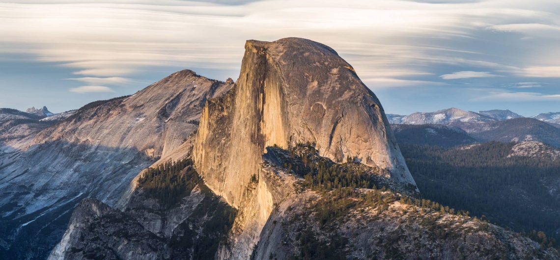
Half Dome, California:
Half Dome, located in Yosemite National Park, is famous for its distinctive shape and challenging hike. The cable route to the summit provides stunning panoramic views.
The granite batholith known as Half Dome is situated in Yosemite National Park’s eastern region. The term comes from the dome’s appearance of being divided. It was known as “Tis-sa-ack” (cleft rock) by the Ahwahnechee people.
The Half Dome soars to an elevation of 2,694 meters (8,839 feet) above sea level. Throughout the whole United States, this is one of the most identifiable rocks. Centuries of wind and water have worn the granite’s surface smooth.
The history of climbing Half Dome is extensive; Greg Anderson made the first ascent of it in 1875. Anderson bored holes in the granite face and fastened bolts there. The National Park Service declared Half Dome a wilderness area in 1919 and set stringent guidelines for dome climbing.
To hike Half Dome these days, one needs to get permission. You have to utilize the famous Ferrata route’s fixed cable system to climb the dome. It’s one of the scariest walks in the world because of the part of the wire with the steep plunge.
The Tetons, Wyoming:
The Grand Teton and its neighboring peaks form the Teton Range in Wyoming’s Grand Teton National Park. Towering above pristine alpine lakes and lush meadows, they offer outstanding hiking and mountaineering opportunities.
The breathtaking mountain range known as the Teton Range, or simply the Tetons, is situated in the western region of the U.S. state of Wyoming. It is renowned for its craggy peaks, immaculate lakes, and a plethora of species. It is a component of the greater Rocky Mountains range.
Grand Teton, which is located at an elevation of 13,775 feet (4,199 meters), is the highest peak in this range. The range lies just west of Jackson, Wyoming, and spans around 40 miles (64 kilometers) in all directions. Grand Teton National Park, which includes a large portion of the mountain range and its surroundings, is notably shaped by the range as well.
Mount Whitney, California:
Mount Whitney is the highest summit in the contiguous United States, reaching 14,505 feet (4,421 meters). Hikers flock to the renowned Whitney Portal Trailhead for a chance to summit this majestic peak.
Situated in California’s Sierra Nevada mountain range, Mount Whitney is a magnificent summit. At 14,505 feet (4,421 meters) above sea level, it is the highest mountain in the contiguous United States.
Josiah Whitney, the state geologist of California, inspired the name Mount Whitney. In 1864, Whitney was the principal sponsor of a geological expedition. The popular 22-mile (35-kilometer) Mount Whitney path leads hikers to the summit of the peak today.
The John Muir Wilderness Area, which is home to alpine meadows, lakes, and woods, is where Mount Whitney is situated. Numerous endangered animals can be found here, such as the Sierra Nevada bighorn sheep.
Mount Baring, Washington:
Nestled in the Central Cascades of Washington, Mount Baring is a rugged and picturesque mountain with numerous alpine lakes surrounding its base.
One of the most beautiful peaks in the Cascade Range is Baring Mountain. Mount Index was the name given to it until 1917. To avoid confusion with another peak known as West Index peak, the name was changed.
The mountain has a striking appearance and is the third steepest peak in Washington. In spite of this, it is just 1, 868 meters (6127 feet) above sea level. The conventional track is not extremely challenging and does not follow the Northwest Ridge route. There aren’t many parts that involve scrambling. There is a difficult climbing path in the Northeast.
Base jumping is very common at Mount Baring. In 2001, the first base jumpers took off from this peak.
Mount Shasta, California:
The iconic Mount Shasta is a striking stratovolcano that dominates the northern California landscape. It’s a popular destination for climbers and hikers.
California’s Siskiyou County is home to Mount Shasta. At 14, 179 feet (4,322 meters), it is California’s fifth-highest summit. It is located at the Cascade Mountain range’s southernmost point. Every 600–800 years, this potentially active volcano erupts.
This stratovolcano seems layered due to its four overlapping cones. Shastina, a tiny satellite cone, is one of these cones. The volcano is a component of the Shasta-Trinity National Forest, along with its environs.
The history of the Shasta region is extensive. This area was inhabited by humans around 7,000 years ago. The peak was a well-known landmark along the Native American trading route that connected the Pacific Northwest with the Central Valley in the 1820s.
Maroon Bells, Colorado:
The Maroon Bells are two striking peaks in the Elk Mountains of Colorado, known for their maroon-colored rock. The Maroon Lake, with the reflection of the peaks, creates an iconic image.
The Colorado Elk Mountains are home to the two 14,000-foot mountain peaks known as the Maroon Bells. They rank among the state’s most frequently photographed natural landmarks.
Geological processes spanning over 300 million years have produced the Maroon Bells. made up of mudstone, limestone, and shale in combination. The weathering of haematite, a mineral rich in iron, gives these stunning mountains their distinctive red color. The reddish hue and distinctive bell-like form of the mountains—which are most striking at sunrise and sunset—have earned them the moniker.
Maroon Bells-Snowmass Wilderness region is the designation for the surrounding region. Some of Colorado’s top hiking trails, including day walks and overnight trips, are located here. Every season, around 300,000 people come to this area.
Mount Bona, Alaska:
Mount Bona, located in the Wrangell Mountains of Alaska, ranks as one of the tallest peaks in North America. Its remote location adds to its allure for serious climbers.
The tallest volcano and the fifth-highest peak in the United States is Mount Bona 16, 550 feet / 5, 029 meters. Part of the Wrangell-Saint Elias National Park and Preserve, it is situated in the Saint Elias Mountains.
When Prince Luigi Amedeo, the Duke of Abruzzi, made the first climb of Mount Saint Elias, from where Mt. Bona is visible, he called the peak. He named her “Bona” in honor of his racing boat.
About 10,000 years have passed since Mount Bona’s last known eruption, making it a dormant volcano. Glaciers and ice fields cover the peak almost entirely. The typical path to the peak takes many days to complete and calls for advanced climbing abilities. There are other subsidiary summits of Mount Bona, such as Mount Churchill and Mount Blackburn.
Mount Foraker, Alaska:
Mount Foraker is an impressive peak in the Alaska Range, and it is often overshadowed by Denali’s fame. Nevertheless, it provides a challenging climbing experience.
In the Alaska Range, Mount Foraker is a 5,304-meter (17,400-foot) summit. Situated in Denali National Park, it is the third-highest mountain in the United States and the second-highest peak in Alaska. It is situated nearly exactly above the base camp used to ascend Denali.
Joseph B. Foraker was honored with the mountain’s name in 1899. The Ohio senator in the United States. It was known by two names among the Koyukon natives: “Menlale” (Denali’s spouse) and “Sultana” (the lady). Sultana Ridge is the name given to the kinder, northeastern ridge.
Both a north and a south peak atop Mount Foraker. August 1934 saw the first successful ascent of both peaks.
Mount Mitchell, North Carolina:
Mount Mitchell stands as the highest peak in the eastern United States. The summit provides expansive vistas of the Appalachian Mountains.
The highest summit in the United States east of the Mississippi River is Mount Mitchell, at 6, 684 feet (2,037 meters). It is a portion of North Carolina’s Black Mountains, an Appalachian Mountain subrange.
Elisha Mitchell is honored by the mountain’s name. Midway through the 1800s, Mitchell, a professor at the University of North Carolina, estimated its height. This mountain is known as Attakulla in Cherokee.
The thick spruce-fir forest that covers Mount Mitchell is unique to the Southern Appalachian Mountains and is only found at high elevations. The top of the mountain is a sub-alpine landscape with rocky ground and wind-tossed trees. Numerous endangered bird species may be found there, such as the Red Crossbill and the Northern Saw-whet Owl.
One of the coldest locations in the Southeastern United States is Mount Mitchell. Even in the summer, the peak is frequently covered in snow and ice, with an average temperature of only 45°F/7°C.
You may hike Mount Mitchell as an add-on while following the Appalachian Trail.
Mount Borah, Idaho:
Idaho’s Mount Borah is the state’s highest point. Its steep and rocky terrain draws adventurous climbers and hikers.
Part of the Lost River Range in the Salmon-Challis National Forest is Mount Borah, often known as “Beautiful Peak.” It is the highest point in Idaho, rising 3,859 meters (12,662 ft) above sea level. William Borah, a well-known state senator and politician from Idaho, is the man behind the mountain’s name.
This region is renowned for its difficult hiking paths and rough topography. The typical path to the top involves hiking 3.5 miles (5.6 km) and gaining more than 5,000 feet in height. The mountain is well-liked by seasoned climbers and offers several tough climbing routes. The highest of the “Nine Peaks,” a collection of nine over 12,000-foot mountains in Idaho, is Borah Peak. There is a seismic zone around the peak. A large avalanche on the north face of the mountain was triggered by an earthquake of magnitude 7.3 in 1983, resulting in several fatalities.
How much does it cost to climb Mount Kilimanjaro in $ American Dollars (USD)?
Sure! Here is the cost breakdown for climbing Kilimanjaro in ($) USD:
- Marangu route– 6 days from USD 1,695:
- Machame route – 7 days from USD 1,985:
- Crater Camp route– 9 days from USD 2,895:
- Rongai route – 7 days from USD 1,885:
- Lemosho route– 8 days from USD 2,350:
- Northern Circuit route – 9 days from USD 2,545:
Please note that the prices mentioned are approximate and can vary based on various factors like the number of climbers, specific tour operators, inclusions, and seasonal variations. It’s essential to choose a reputable tour operator that provides experienced guides, proper equipment, and a safe climbing experience. Read more on how much it costs to climb Mount Kilimanjaro.
![]()