The following are the more common health concerns that occur on Kilimanjaro. Majority of individuals come out of their mountain experience without encountering any of these issues, except for some sleep deprivation. Blisters, naturally, are another common complaint. Taking simple precautions can prevent the common health problems associated with African climbing expeditions on Kilimanjaro. Rapid changes in humidity and temperature can lead to coughs and colds, along with flu-like symptoms from inhaling cold air at high altitudes. Discomfort can be eased by taking aspirin, gargling with warm salt water, and using anesthetic or menthol throat lozenges. Hydration is also important. Tranquil Kilimanjaro advises informing your guide about these problems as they can easily be mistaken for the onset of altitude sickness. Phlegm, green or pinkish mucus, or chest pain could indicate bronchitis requiring antibiotics, or pneumonia or HAPE necessitating immediate evacuation. Inadequate clothing puts you at risk of exposure, whether it be from sunstroke or hypothermia. In relatively mild conditions, exhaustion, dehydration, and insufficient food intake can exacerbate these risks. Even porters are at risk of frostbite on icy slopes. It is crucial to make sure that everyone is dressed warmly, with warm hats, thick gloves and socks, and that facial skin is either covered or insulated with Vaseline in freezing conditions, especially in high winds, or protected from sunburn with screening lotion. Minor frost nip can be relieved by tucking affected fingers into warm armpits, while more severe numb, white patches necessitate painful thawing in warm water once shelter is reached. Snow blindness can be treated with aspirin, eye drops, and rest in a dark place. Once shivering begins due to exposure, your pulse slows down and you will rapidly lose body heat, leading to poor coordination, hallucinations, and collapse. Immediate warmth is essential. Finding shelter, using a sleeping
The following are the more common health concerns that occur on Kilimanjaro. Majority of individuals come out of their mountain experience without encountering any of these issues, except for some sleep deprivation. Blisters, naturally, are another common complaint. Taking simple precautions can prevent the common health problems associated with African climbing expeditions on Kilimanjaro. Rapid
It is a mentality carried by a majority of people who go to Kilimanjaro to want to reach its summit. But this involves an extremely tough final ascent at high altitude. With the room available in the article, I will not focus on the real physical effects of altitude but rather, concerns about such effects. The summit night’s challenge and the final push are typically the main obstacles to reaching that peak. They are thought by many to be the toughest part of the climb. In addition to this, every climber on her way up that final ascent must conquer the thoughts in her head. Following this final, gruelling climb from the Barafu camp or Kibo Hut, you will spend the rest of the evening attempting to sleep in an A-frame hut or a tent at high camp before starting your summit night at midnight. Right from the start of your summit bid, the cold mountain air nips at your fingers, making even a simple task such as fidgeting with the strap on your backpack almost unbearable. At your feet, the soil can be soft and slippery, with a wrong step or slip potentially causing you to tumble off the path and down into the unknown. Anyone climbing Mount Kilimanjaro will have an idea of the physical challenges awaiting them on the mountain. Days of hiking for up to 7 to 9 hours or more with only the air to breathe. Achieving the level of physical readiness necessary to conquer Kilimanjaro’s trekking challenge will be tough in itself and is something I have discussed at length in a previous post on how to physically prepare for your Mount Kilimanjaro expedition. However, the mental challenges associated with climbing a 5,895-meter-high mountain cannot be underestimated. Indeed, for many, it is the mental
It is a mentality carried by a majority of people who go to Kilimanjaro to want to reach its summit. But this involves an extremely tough final ascent at high altitude. With the room available in the article, I will not focus on the real physical effects of altitude but rather, concerns about such effects.
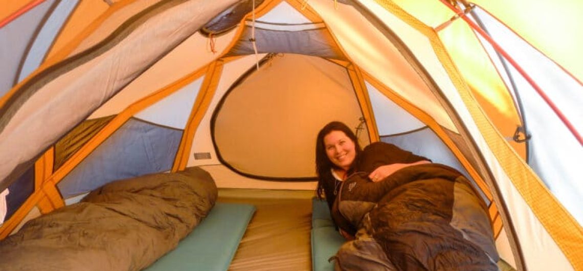
Sleeping on Mount Kilimanjaro can be a challenging task due to its high altitude and low oxygen levels. These factors can greatly impact your body's ability to rest effectively, resulting in nights filled with restlessness and sleep deprivation. In order to ensure a good night's sleep on the mountain, it is crucial to take certain components into consideration when creating your sleeping area. Taking the necessary steps to prepare your body for sleep is also essential for optimal rest. In this comprehensive article, we will delve deep into the best practices for achieving quality rest on Mount Kilimanjaro. We will explore both the necessary elements for creating an ideal sleeping environment and various techniques that will help optimize your body's readiness for sleep. By implementing these invaluable tips, you will greatly enhance your chances of having a rejuvenating and restful sleep experience. One of the key aspects we will discuss is the importance of choosing the right sleeping gear. From selecting the appropriate sleeping bag that provides insulation and comfort to investing in a reliable sleeping pad that offers cushioning and support, we will guide you in making the perfect choices for a restful night's sleep. You will also learn the significance of wearing suitable clothing to protect yourself from the cold temperatures and how to properly layer your garments to regulate your body temperature during slumber. Creating an ideal sleeping environment on Mount Kilimanjaro goes beyond just having the right gear. We will enlighten you on the significance of choosing the perfect camping spot, whether it be a designated campsite or a remote location off the beaten path. You will discover how factors such as terrain, wind direction, and proximity to water sources can greatly affect the quality of your sleep. We will also provide insights on setting up
Sleeping on Mount Kilimanjaro can be a challenging task due to its high altitude and low oxygen levels. These factors can greatly impact your body’s ability to rest effectively, resulting in nights filled with restlessness and sleep deprivation. In order to ensure a good night’s sleep on the mountain, it is crucial to take certain
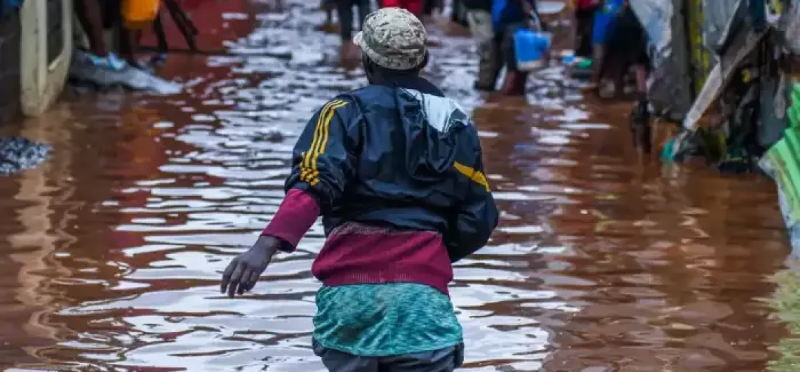
The arrival of Qatari Aircraft in Kilimanjaro, Bringing Aid for Tanzania Flood Victims Aiming to provide support to those affected by the floods and landslides in northern Tanzania has been a relief, especially to residents of the greater Kilimanjaro Region. The aircraft from the Qatar Armed Forces touched down in Kilimanjaro carrying a significant quantity of aid, weighing 49 tons and consisting of essential food and medical supplies. All the aid was generously provided by Qatar Charity. Upon arrival, the assistance was promptly received by various Tanzanian government officials and His Excellency Fahd bin Rashid Al Muraikhi, the Ambassador of the State of Qatar to the United Republic of Tanzania. At least 155 killed in Tanzania as heavy rains pound East Africa The heavy and incessant rainfall that has been pouring down in Tanzania has had a significant and far-reaching impact, affecting well over 200,000 individuals and an astonishing 51,000 households, as recently mentioned by the esteemed prime minister of the country. The consequences of this devastating weather have been nothing short of catastrophic, with the streets of Dar es Salaam now fully submerged under the relentless flooding, to the point where even public minibuses have been entirely swallowed up by the torrents of water. Taking the matter seriously, the prime minister felt compelled to address the distinguished Parliament, shedding light on the underlying cause behind this meteorological phenomenon. He unequivocally attributed the intensified rainy season and the subsequent floods to the notorious El Nino climate pattern that has, unfortunately, wreaked havoc on the region. Elaborating further, he elaborated that the downpours, coupled with ferocious and unyielding winds, have unleashed an unfathomable level of destruction upon the area, ruthlessly damaging and obliterating key infrastructures such as roads, bridges, and even railways. Furthermore, the prime minister did not shy away from
The arrival of Qatari Aircraft in Kilimanjaro, Bringing Aid for Tanzania Flood Victims Aiming to provide support to those affected by the floods and landslides in northern Tanzania has been a relief, especially to residents of the greater Kilimanjaro Region. The aircraft from the Qatar Armed Forces touched down in Kilimanjaro carrying a significant quantity
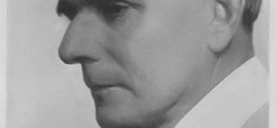
Gilman's Point, found on the edge of Mount Kilimanjaro's magnificent crater, stands boldly and proudly as the least elevated among the three highest and most awe-inspiring points on the majestic peak. Positioned at an astonishing approximate height of 18,638 feet (5,681 meters), this remarkable and noteworthy location was bestowed with its distinguished and cherished name in deep and heartfelt tribute to the legendary and highly esteemed Clement Gillman, an extraordinary and profoundly influential East African engineer and geographer, whose indelible contributions continue to shape and inspire. His headstone epitaph reads:- "To THE MEMORY OF CLEMENT GILLMAN 26th NOV 1882-5th OCT. 1946 Who led a commonsense and therefore happy life because he stubbornly refused to be bamboozled by his female relations, by his scientific friends and by the rulers, spiritual and secular of the society into which without his consent he was born." Who Was Clement Gillman? Clement Gillman, born in Spain on November 26, 1882, was the offspring of an Anglo-Swiss father and a German mother. He spent his formative years in Germany, receiving education in Switzerland, which set the stage for a life filled with exploration and wanderlust. In 1905, he embarked on a journey to East Africa, where he took on the role of a survey engineer for the Central Railway construction. This expedition marked the commencement of a long-standing connection with the continent. Over the span of four decades, Gillman called East Africa his home, undeterred by the turmoil of the World Wars and even enduring internment as a civilian prisoner. Throughout, he remained dedicated to the pursuit of scientific exploration. The post-war years saw Gillman offering his expertise as a water consultant to the government, while his twilight years were dedicated to academic pursuits. In 1946, his passing signified the end of a career that had
Gilman’s Point, found on the edge of Mount Kilimanjaro‘s magnificent crater, stands boldly and proudly as the least elevated among the three highest and most awe-inspiring points on the majestic peak. Positioned at an astonishing approximate height of 18,638 feet (5,681 meters), this remarkable and noteworthy location was bestowed with its distinguished and cherished name