Just a few kilometres north of the equator, on the border between Uganda and Congo, is Rwenzori Mountains National Park. You may get to the park trailhead at Ruboni from Kampala by travelling either north through Fort Portal (375 kilometres) or south through Mbarara and Queen Elizabeth National Park (450 kilometres). Both routes are accessible from Kampala. Located 25 kilometres north of Kasese town, Nyakalengija is 17 kilometres from the Kasese-Fort Portal road.
The Rwenzori Mountains, also known as the “Mountains of the Moon,” are a majestic range in East Africa, spanning the border between Uganda and the Democratic Republic of the Congo (DRC). Despite being situated near the equator, these mountains are renowned for their stunning natural beauty, rich biodiversity, and unique glacial features.
Located in the Albertine Rift, the Rwenzori Mountains are part of the East African Rift system, stretching from the Red Sea to Mozambique. The range stretches over 120 kilometres (75 miles) and includes several peaks, with Mount Stanley being the highest at 5,109 meters (16,763 feet) above sea level. Mount Stanley’s highest peak, Margherita Peak, is the third highest point in Africa, after Mount Kilimanjaro and Mount Kenya.
The Rwenzori Mountains are characterized by their distinctive alpine and afro-montane ecosystems, which support diverse flora and fauna. These mountains are home to numerous endemic species, including the Rwenzori turaco, Rwenzori apalis, and Rwenzori red duiker. The range’s lower slopes are covered in lush montane rainforests, while higher elevations feature bamboo forests, heath, and moorland. Above 4,500 meters (14,700 feet), the landscape transforms into an otherworldly realm of giant lobelias and groundsels, punctuated by glacial valleys and pristine alpine lakes.
The Rwenzori Mountains are also renowned for their glaciers, among the few remaining equatorial glaciers worldwide. However, due to climate change, these glaciers have been rapidly receding, posing a significant threat to the region’s hydrology and biodiversity.
In addition to their natural beauty, the Rwenzori Mountains hold cultural significance for the local communities, including the Bakonzo and Bamba people, who have inhabited the region for centuries. These communities have developed unique cultural practices and traditions closely tied to the mountains, including rainmaking and worship rituals.
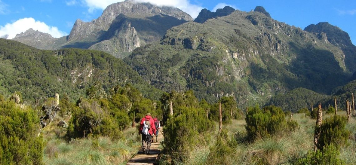
Despite their remote location and challenging terrain, the Rwenzori Mountains attract adventurous trekkers and mountaineers worldwide. Several trekking routes, including the popular Central Circuit and Kilembe Trails, offer opportunities to explore the region’s stunning landscapes and its diverse wildlife.
Overall, the Rwenzori Mountains are a true natural wonder, offering a glimpse into an ancient and pristine wilderness that continues to captivate and inspire all who venture into its rugged terrain.
How to Access Kasese & Rwenzori Mountains National Park
Mt. Rwenzori National Park is situated in an adequate location in the southwestern region of Uganda. It is possible to reach the park by traveling through any of the countries that are adjacent to Uganda; however, Rwanda and Uganda are the most suitable options.
It is possible for travelers to make a transfer from Kigali International Airport to Uganda’s Kisoro, and then proceed to Mt. Rwenzori National Park from there. Nevertheless, there is also the possibility of taking a transfer from the Entebbe International Airport in Uganda to the South Western Region of the country in order to visit the magnificent Mountain.
By Road from fort portal.
When traveling from Kampala to Kasese, the journey will take approximately seven and a half hours if you take the public transportation option of taking a bus through Fort Portal, which is the most clean city in Uganda.
The majority of bus parks are located in and around Kampala, such as the one that Link Buses utilizes if it is along that route.
When you are traveling privately in the cars provided by Rwenzori Mountaineering service, which are 4×4 Jeeps (Safari Landcruisers and Toyota Rav4), it is possible that you will experience a lesser amount of time of around that amount.
By Air
If, on the other hand, you took a plane, the journey would only take you approximately an hour and a half. Get in touch with your travel agency to make reservations for a flight to Kasese. You will begin your journey to Kasese by making your first stop at Fort Portal, from whence you will proceed south. It takes fifteen minutes to go to the gate from Mubuku, which is located to the north of Kasese. Once you have passed the Bugoye power plant, you can organize transportation on your own. There will be no difficulty in obtaining porters, guides, and other individuals who are able to assist you.
The Reservation section of Rwenzori Mountaineering Service is able to assist you in making reservations with Aero Link, a domestic airline that provides flights to Kasese as well as other national parks such as Queen Elizabeth, Bwindi Impenetrable, and Murchison Falls.
How to get to Rwenzori Mountains
Getting to the Rwenzori Mountains typically involves traveling to the surrounding towns and villages in Uganda or the Democratic Republic of the Congo (DRC), as there are no direct transportation options to the mountains themselves. Here are some common ways to reach the Rwenzori Mountains:
1. By Air: The nearest international airports to the Rwenzori Mountains are Entebbe International Airport in Uganda and Kigali International Airport in Rwanda. From these airports, you can take domestic flights or arrange ground transportation to reach towns near the mountain range, such as Kasese or Fort Portal in Uganda.
2. By Road: Most visitors travel to the Rwenzori Mountains by road. From major cities like Kampala in Uganda or Kigali in Rwanda, you can hire a private car, take a public bus, or use a tour operator to arrange transportation to the mountain region. The journey typically involves traveling through scenic countryside and rural villages, with options to stop and explore along the way.
3. From Kasese: Kasese is a major town located near the foothills of the Rwenzori Mountains in Uganda. It serves as a gateway to the mountain range and is the starting point for many trekking expeditions. From Kasese, you can hire a local guide or join a guided tour to access the trailheads and begin your trek into the mountains.
4. From the DRC: If you’re interested in exploring the Congolese side of the Rwenzori Mountains, you can travel to the town of Beni or the nearby Virunga National Park. From there, you can arrange local transportation or guided tours to access the mountains.
It’s important to note that traveling to the Rwenzori Mountains requires careful planning and preparation, as the region is remote and the terrain can be challenging. It’s recommended to arrange transportation and accommodations in advance, as well as to hire experienced guides or join organized tours for safety and logistical support during your visit.
Climb the Rwenzori Mountains in Uganda
Geographical Location
The Rwenzori Mountains are located in western Uganda and border the Democratic Republic of Congo. They are strategically placed astride the equator but due to their towering height, have snow-capped peaks that would generally be associated with a greater distance from the equator. They lie 70 km north of Lake Edward and the Mountains of the Moon are separated from the Ruwenzori range in the eastern Democratic Republic of the Congo. The Ruwenzori range is over 120 km long and 65 km wide. The Ruwenzoris are composed of three different types of rock: igneous intrusive rocks, metamorphic rocks resulting from the transformation of the first type due to heat and pressure, and sedimentary rocks which are the remains of the others and form the majority of the higher peaks. The type of rock in the Ruwenzoris is very important in understanding the soil and vegetation in the range as well as the impact that man has had and continues to have, since different types of rock have different properties and are more or less prone to certain types of erosion and are more or less fertile.
Rwenzori on the Google Map
Elevation
In the countries of Uganda and the Democratic Republic of the Congo, the Rwenzori Mountain range straddles. Like Kilimanjaro to the east, the equator is several miles south. Unlike other equatorial mountains, these have glaciers and are not volcanic. The highest Rwenzori peaks are permanently snow-capped. Margherita Peak, one of the highest peaks on this mountain, finds itself in one of the few locations in the world that receives snow all year round. During the last Ice Age, the Rwenzori was a true alpine mountain. But with warming and melting, the ice has greatly reduced. It is estimated that over 80% of the ice that existed 100 years ago has already melted. Changes in global temperature and regional environment have placed the Rwenzori on the front line of research on glacier retreat and its impact. It is cited as a dramatic example of the effects of global warming on the alpine environment. The Rwenzoris are located on the border between Uganda and the Democratic Republic of the Congo. The Rwenzori Mountain constitutes a classic glacial erosion mountain. The range is about 120 km long and 65 km wide. It has 6 permanently snow-capped peaks. The Margherita peak, which is the third highest peak in Africa, is also the highest peak in the Rwenzori. Margherita is 5109 m above sea level. It is named after Queen Margherita of Italy. The Rwenzori mountain is unique because of its location. For a mountain range that is so close to the equator, it is amazing the high elevation and the amount of snow and glaciers that the Rwenzori possess. All other mountains by the equator are not as high, and this gives the Rwenzori its unique climate.
Distance of the Rwenzori Mountains from various Towns and Cities
The distance of the Rwenzori Mountains from various locations is as follows:
- Kasese: Kasese is one of the closest towns to the Rwenzori Mountains. The distance from Kasese to the mountains varies depending on the specific trailhead or entrance point, but it generally ranges from about 20 to 40 kilometres (12 to 25 miles).
- Entebbe Airport: Entebbe International Airport is located near the capital city of Kampala in Uganda. The distance from Entebbe Airport to the Rwenzori Mountains is approximately 400 to 500 kilometres (250 to 310 miles), depending on the route taken and the specific destination within the mountain range.
- Kigali: Kigali is the capital city of Rwanda, located to the south of Uganda. The distance from Kigali to the Rwenzori Mountains is approximately 500 to 600 kilometres (310 to 370 miles), depending on the route chosen and any border crossings that may be required.
- Kampala: Kampala is the capital and largest city of Uganda, situated in the central part of the country. The distance from Kampala to the Rwenzori Mountains is approximately 300 to 400 kilometres (185 to 250 miles), depending on the specific destination within the mountain range and the route taken.
- Jinja: Jinja is a town located in southeastern Uganda, known for its location near the source of the Nile River. The distance from Jinja to the Rwenzori Mountains is approximately 400 to 500 kilometres (250 to 310 miles), depending on the route chosen and any detours required.
- Nairobi: Nairobi is Kenya’s capital city, located east of Uganda. The distance from Nairobi to the Rwenzori Mountains is significant, spanning approximately 1,000 to 1,200 kilometres (620 to 745 miles), depending on the specific route taken and any border crossings that may be required.
Related articles
![]()