
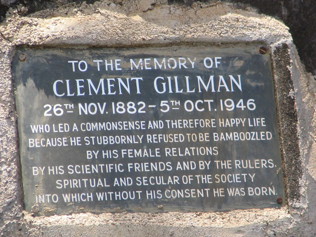
Gilman’s Point, found on the edge of Mount Kilimanjaro‘s magnificent crater, stands boldly and proudly as the least elevated among the three highest and most awe-inspiring points on the majestic peak. Positioned at an astonishing approximate height of 18,638 feet (5,681 meters), this remarkable and noteworthy location was bestowed with its distinguished and cherished name in deep and heartfelt tribute to the legendary and highly esteemed Clement Gillman, an extraordinary and profoundly influential East African engineer and geographer, whose indelible contributions continue to shape and inspire. His headstone epitaph reads:-
“To THE MEMORY OF CLEMENT GILLMAN 26th NOV 1882-5th OCT. 1946
Who led a commonsense and therefore happy life because he stubbornly refused to be bamboozled by his female relations, by his scientific friends and by the rulers, spiritual and secular of the society into which without his consent he was born.”
 Who Was Clement Gillman?
 Who Was Clement Gillman?
Clement Gillman, born in Spain on November 26, 1882, was the offspring of an Anglo-Swiss father and a German mother. He spent his formative years in Germany, receiving education in Switzerland, which set the stage for a life filled with exploration and wanderlust. In 1905, he embarked on a journey to East Africa, where he took on the role of a survey engineer for the Central Railway construction. This expedition marked the commencement of a long-standing connection with the continent. Over the span of four decades, Gillman called East Africa his home, undeterred by the turmoil of the World Wars and even enduring internment as a civilian prisoner. Throughout, he remained dedicated to the pursuit of scientific exploration. The post-war years saw Gillman offering his expertise as a water consultant to the government, while his twilight years were dedicated to academic pursuits. In 1946, his passing signified the end of a career that had a profound impact on the understanding of East African geography. His enduring legacy can be seen in the maps and publications he produced, which remain essential references for the study of East African geography.
1909 Kilimanjaro Expedition
During the early 1900s, Kilimanjaro proved to be an extraordinary and formidable undertaking for adventurers and cartographers alike. In those days, there burned a fiery ambition to conquer uncharted territories, despite the scarcity of technological advancements. It was during this era that Gillman embarked on his initial expedition to scale Kilimanjaro, a mere few years after arriving in East Africa in 1909. Unfortunately, specific details about the exact path he traversed or the obstacles he encountered are not known. Nevertheless, even though Gillman did not succeed in reaching the summit, his endeavor served as a testament to his unwavering determination and fascination with the remarkable geographical wonders of Kilimanjaro.
1921 Kilimanjaro Expedition
In 1921, an extensive expedition led by Gillman was launched with the goal of conquering the mighty Kilimanjaro. The expedition’s primary objective was to gather geographical and scientific data about the mountain. Scaling to the peak served as a means of collecting information on the altitude and environmental conditions of the majestic peak. Notably, this venture took place after the conclusion of World War I, during a time when control of the region transitioned from Germany to Britain. Gillman’s successful ascent on Kilimanjaro marked the first British conquest of the mountain. On October 19, 1921, the team initiated their critical move, aiming towards the summit situated at 19,341 feet (5,895 meters) above sea level. However, Gillman fell short on the icy upper reaches. Nonetheless, he managed to reach the rim of the crater and left the Union Jack flag as evidence of his remarkable achievement. This notable location, positioned at an elevation of 18,638 feet (5,681 meters), later became known as Gilman’s Point..
The Naming of Gilman’s Point
Originally unnamed, Gilman’s Point was discovered by German climbers Fritz Klute and Eduard Oehler in 1912 during their mapping expedition. In recognition of his significant contributions to the exploration of Kilimanjaro and his extensive work in East African geography, the site was later named after Gillman. Despite his initial objections, Gillman eventually took great pride in this honor. His extraordinary contributions continued until his passing, which occurred on October 5, 1946, during a flight from Dar es Salaam to Moshi. Remarkably, he passed away within sight of Kilimanjaro, with his pencil in hand and his notebook on his knee, symbolizing his profound connection to the mountain he knew so intimately. Gillman’s influence was not limited to Kilimanjaro’s slopes. His meticulous surveys and studies laid the foundation for future developmental projects. Furthermore, his expertise in railway engineering and hydrology provided valuable insights into the environmental opportunities in East Africa. His publications and maps have since become essential resources in the field, serving as pillars of knowledge for researchers and enthusiasts alike.
His Works
“Gillman of Tanganyika, 1882-1946: The Life and Work of a Pioneer Geographer” by B.S. Hoyle, courtesy of OSPA, offers a captivating exploration into the remarkable life of Clement Gillman, a pioneering figure in East African geography. Born in 1882, Gillman’s fascinating journey unfolds through his diaries and field research, shedding light on his significant contributions to geographical studies in Tanganyika.
Despite being British by nationality, Gillman’s upbringing in Germany and Switzerland, influenced by his German heritage, shaped his worldview. His arrival in German East Africa in 1905 marked the beginning of a lifelong connection to the region, where he immersed himself in the environment and culture. Revered as “the man who was Tanganyika,” Gillman’s impact extended across the political, cultural, and social landscape of the territory.
Through his diaries, readers gain insight into Gillman’s passionate pursuits and his role in shaping the development of German East Africa and later, Tanganyika, until the end of World War II. His dedication to research and his profound connection to the land are poignantly highlighted, offering valuable lessons for those engaged in development planning in East Africa.
Even in his later years, Gillman’s commitment to his work remained unwavering. Tragically, he passed away during an air journey to Moshi, with Kilimanjaro in sight, symbolizing his lifelong bond with the majestic mountain. The book is enriched with photographs from the Gillman family, providing a visual narrative of Gillman’s life and legacy as a pioneer in East African geography. As readers delve into Gillman’s story, they are transported into the world of a visionary whose profound impact continues to resonate in the region.
Fun Fact
On Kilimanjaro, Gillman used the Siedepunkt-Meßmethode, a technique that relies on the boiling point of water to measure altitude. Taking into account that the boiling point of water decreases by around 10°C for every 3,000 meters in height, Gillman deduced that at Gilman’s Point, the water would reach boiling temperature at 81.06°C..
“Siedepunkt-Meßmethode” translates to “boiling point measurement method” in English. This method is commonly used in chemistry and physics to determine the boiling point of a substance, which is the temperature at which the vapor pressure of the liquid equals the atmospheric pressure.
![]()