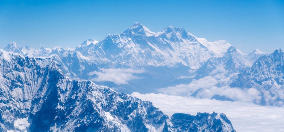
The formation of Everest began about 60 million years back to create the highest mountain in the world, a mountain that is primarily made up of numerous layers of rock that have been folded over each other, forming what is known as nappes. At lower elevations, metamorphic schists and gneisses dominate the mountain’s composition, topped by igneous granites. As we ascend higher, we come across sedimentary rocks with origins in the marine environment, remnants of the ancient floor of the Tethys Sea that closed after the collision of the two plates. Of particular interest is the Yellow Band, a striking limestone formation that is visibly prominent just below the summit pyramid.
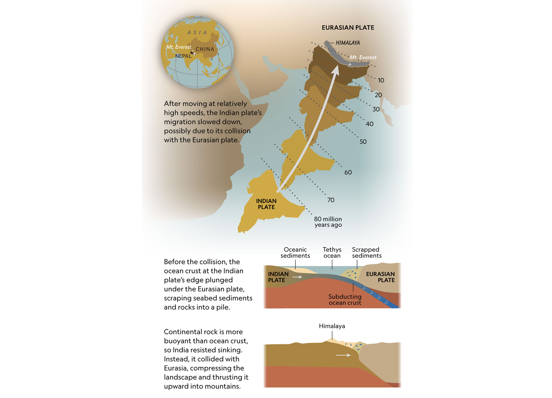
The Eurasian tectonic plate extends all the way from the Near East to the eastern part of Russia and from Mongolia to the Arctic Ocean. The Indian plate was joined with the Australasian plate. This giant-sized Indo-Australian plate was broken up into two plates: the Indian plate and the Australian plate. This Indian plate was heading north very quickly at the rate of 15cm/year, about 40 million years ago. As the Indian plate was travelling north, it was met with the Asian plate. The Indian and Asian plates collided, and because the Indian plate was heavier, it was subducted beneath the Asian plate. The southern edges of the Asian plate were dragged downwards, forming the Himalayan range. This process is still occurring today.
As the Indian plate continued to move north, it pushed the Asian plate along the low plains of the Indian subcontinent. The Indian plate was still being driven downwards into the mantle. The rocks were being melted and eventually created magma. As the pressure built, the magma was forced out through the Asian plate and formed a range of mountains. This is the growth of the Himalayan range. This process is also still occurring today and is evident in the many earthquakes that are reported each year.
Climbers who reach the peak of Mount Everest might not be aware, but hidden beneath the layer of snow lies a vast expanse of gray rocks. These rocks were once part of the ocean floor and have found their way to this unexpected location, nearly 30,000 feet above sea level, due to the gradual movement of tectonic plates. These plates, which are solid slabs of rock constituting Earth’s outer shell, are in a constant state of motion, constantly rearranging the surface features. In some areas, the plates separate, resulting in the formation of valleys, while in others, they collide, thrusting mountains upward. Mount Everest, located on the border of Tibet and Nepal, came into existence as a result of a collision between the Indian and Eurasian tectonic plates millions of years ago. This collision crumpled the landscape and formed the Himalaya range, stretching for about 1,500 miles. Although many aspects of this continental collision remain a mystery, the process continues to this day, which contributes to the ever-changing altitude of Everest.
Tectonic Plate Movements
Tectonic plates are huge segments of the Earth’s crust and upper mantle that move on the semi-fluid asthenosphere under the influence of the convection currents and forces generated at the deep-seated interior of the Earth. The modern theory of plate tectonics (or the “moving plates” theory) has now brought together the concept of continental drift and the knowledge of the existence of seismic and volcanic activity into a unified theory. There are seven principal plates that make up a little more than 95% of the Earth’s surface area. There are roughly another dozen minor plates with various degrees of scientific consensus. The Indian plate, around 70 million years ago, was part of the southern hemisphere supercontinent Gondwana. It had already split from Australia, Antarctica, and New Zealand but had yet to collide with the Asian region. The Indian plate is of particular interest to the study of the Himalayas due to its geographic location and the role it played in the formation of the mountain range. Today, the Indian plate accounts for the Indian subcontinent as well as the part of Southeast Asia up to the range of the Himalayas.
 Collision of Indian and Eurasian Plates
 Collision of Indian and Eurasian Plates
The collision of the Indian and Eurasian plates caused the Indian plate to buckle and uplift, resulting in the termination of the Tethys Ocean and being responsible for the significant thickening of the crust to the exceptional elevations found in the Himalaya. During the Cenozoic, the collision of the Indian and Eurasian plates led to the folding and faulting of the regional rocks. Tectonic forces in this area induced the marine sedimentary rocks to become faulted and folded. This resulted in the upwelling of the rocks exposed today in the Himalaya. These are the same rocks that were deposited in marine environments between 3 to 200 million years ago. The rocks have been pushed more than 20 kilometers to the north and to elevations exceeding 6000 meters. Many of these rocks did not reach their present-day locations.
Subduction and Uplift
The crustal rocks carried down into the mantle are subjected to extreme pressures and temperatures and are eventually heated up to around 600-850 °C. Under these conditions, it is thought that the Indian crust started to partially melt. This molten rock is less dense than the surrounding mantle and crustal rocks and therefore starts to rise. As the Tibetan crust is thicker and less dense, it did not undergo much, if any, partial melting and therefore did not rise up into the mantle. This caused the Indian crust to act like a raft and start to float on the more dense Tibetan crust. This is the process of subduction. The Indian crust was carried upwards by the force of the partially melted rocks and the subduction of the Indian plate beneath the Tibetan plate. This carried the Indian crust to depths of around 50-100 km.
The buoyant Indian crust and the partially molten material began to push up through the Tibetan crust in the process known as orogeny. The molten material cooled and solidified between 20-40 km beneath the surface and is thought to have formed a layer of rock called granite. This continued to force the Indian crust upwards and under the Tibetan crust. This continued pressure caused the Tibetan crust to deform and flow plastically at depths of about 15 km. The Indian crust was finally passed through the Tibetan crust and came to rest against the Yarlung Tsangpo Suture Zone about 20 million years ago. This is now where the Himalayan mountain range is located. Here the India plate met the Eurasian plate, as the earlier Tibetan name plate is often referred to as part of the Indian plate. Subduction is still taking place today, as the Indian plate is being forced under the Eurasian plate and is liable for earthquakes in the Himalayan region. This is the process that formed Mount Everest at its present location as the Earth’s highest peak around 8.2 million years ago.
Formation of Himalayan Range
Formative period (0-540 Ma) during the Mesozoic era: Before the formation of the Himalayas, the precursor Indus-Yarlung suture zone separated assemblages of rocks and fossils of plate tectonic provenance, and a marine Tethys Ocean seaway separated the drifting Indian subcontinent from the stable Eurasian continent.
The closure of the Tethys seaway in the Late Cretaceous and Eocene times marked a fundamental shift in the tectonic processes and the onset of the collision of the Indian and Eurasian continents. The ocean sediments then precipitated into the Indo-Asian continental margin and deepwater sedimentology ceased. Initial collision took place during the Paleocene time period (55-65 Ma) south of the suture zone along the leading edge of the Indian plate at the time.
India’s northern drift to its Deccan Traps flood basalts starting during the Late Cretaceous era (67-60 Ma) had resulted in significant structural development of a flexural bulge and uplift, which was further intensified by the impingement of the K/T asteroid impact event.
The collision thickened the Indian lithosphere, disrupting the flat-lying Indo-Asian sedimentary patterns. With the cessation of the northern oceanic convergence and the stalling Indo-Asian indentor, the Indian plate ground to a halt about 40-50 million years ago. Subsequent transgressing and regressing clastic sea patterns during the Cenozoic era mark the dynamic cessation and retreat of the evolving Indian continental margin. This growth of higher topography and alteration of lands proximal to the subduction zone became linked to changing erosion and drainage patterns debated by modern Himalayan geomorphologists.
Growth of Mount Everest
Mt. Everest grew to its present height as recently as 15,000 years ago. This is a late stage in geological terms. The main mass of growth during the early phase was before 25 million years ago. It is believed that over 60 million years ago, the entire mass of limestone, sandstone, and shale was a seabed. The gravel, rocks, and boulders which cover the entire area were an ocean floor that was lifted by the force of the two colliding continents. At this stage, the earth’s crust crumpled into a long-wavelength fold and Everest stood at the bottom of what was a great valley system. As continued pressure forced the fold to rise, the valley was sealed and the sedimentary material was preserved. During the past 25 million years, that sedimentary basin rock was thrust upward, where it was faulted and folded and was heated from the heat of the underlying magma.
The Mount Everest of today is composed of various rock from several different episodes. Marine deposits and sediments from the ancient Tethys Sea were transposed from north to south to form a sequence of lesser Himalaya. Then about 20 million years ago, India collided with Asia and these sedimentary rocks were forced to a vertical posture. This collision is also responsible for the large-scale thrust faulting, which caused huge slices of the sea floor and even portions of the earth’s mantle to the surface. These thrust faults are also exposed in the Khumbu and continue to the Tibetan plateau. An example of such exposed rock can be seen at the Everest base camp where the yellow band is a layer of marble, part of a metamorphosed calcareous sequence. High-grade heating of rock was the next stage in the Everest’s formation. This is seen in the thick hard-igneous intrusive sills that were added to the sequence of rocks, this is exposed under the cover of the Khumbu, and particularly at the Phorste. Finally, the recent orogeny has produced modern Mount Everest. This was caused as the Asian continental plate has continued to collide with the Indian plate. The resultant heavy compression and intense folding and thrusting of rock have forced the crust to rise with large portions of the rocks now exposed at the mountain’s surface. An example of this event is the 1934 thrust fault where the overthrust of the Indian plate slid under Tibet and into its present location. The effects of this collision are still pervasive and easily observable today with large jets and earthquakes still occurring due to the energy of the collision of these two major plates.
The actual summit of Everest is a marine limestone which was created by the remains of ocean life from the Paleozoic and Mesozoic periods. This carboniferous limestone, known as the Qomolangma Formation, was uplifted and thrust to its location in the last 20 million years and continues to be uplifted today. At a rate of approximately 1 cm a year, Everest is still rising. This is due to the movement along the fault line by upthrust of the Indian plate which slides under the Asian plate, taking the limestone with it up to the present day.
Continued Uplift and Erosion:
Over millions of years, the Himalayas continued to experience uplift as the Indian plate pushed further into the Eurasian plate. The process of uplift was accompanied by erosion, as weathering and geological forces gradually wore down the peaks, shaping their rugged contours.
Glacial Activity:
The Himalayas are home to vast glaciers that have played a significant role in shaping the landscape of the region, including Mount Everest. Glacial erosion has carved deep valleys and cirques into the mountainsides, while glacial deposits have contributed to the formation of moraines and other landforms.
Geological Stability:
Despite its dynamic geological history, Mount Everest is currently in a state of relative stability. While the Indian plate continues to push against the Eurasian plate, the rate of uplift has slowed significantly compared to earlier periods of tectonic activity.
Modern Exploration and Understanding:
Mount Everest has long been a subject of fascination and exploration for scientists, geologists, and adventurers. Modern technologies such as satellite imagery, seismic monitoring, and geological surveys have provided valuable insights into the formation and geology of the mountain.
How long have the Himalayas and Mt. Everest existed?
The majestic Himalayas, which include the renowned pinnacle Mount Everest, have graced the Earth for countless millennia. These awe-inspiring mountains owe their creation to the colossal clash between the Indian and Eurasian tectonic plates. Determining the precise age of the Himalayas proves challenging, given the ongoing geological processes of uplift and erosion. Nonetheless, scientists estimate that this formidable mountain range began forming approximately 70 million years ago and continues its growth to this very day, expanding at a rate of around 5 millimeters annually. Turning our attention to the remarkable Mount Everest, it is believed to have materialized approximately 60 million years ago, during the same period of tectonic activity that birthed the Himalayan mountain range.
How old is Mount Everest
The age of Mount Everest is intricately tied to the age of the Himalayas, as it is a part of this vast mountain range. Initially, scientists believed that the Himalayas were formed approximately 55 million years ago, when the Indian and Eurasian plates collided. However, in recent years, doubts have arisen regarding this timeline. It has been proposed that there may have been a pre-existing mountain range in the location of the Himalayas, dating back approximately 500 million years. This suggests that the Indian plate may have collided, formed a mountain range, then receded, only to collide again 55 million years ago, resulting in the formation of Mount Everest. Consequently, it is plausible to consider that Mount Everest may have an approximate age of 500 million years.
Over millions of years, the continued convergence of the tectonic plates resulted in further uplift and the formation of the Himalayan mountain range, of which Mount Everest is the highest peak. Geological processes such as folding, faulting, erosion, and glacial activity also played significant roles in shaping the landscape and contours of Mount Everest.
While the exact duration of Mount Everest’s formation cannot be pinpointed precisely, it is estimated that the mountain took tens of millions of years to reach its current height and form. The ongoing geological processes in the region continue to shape and modify the landscape of Mount Everest and the surrounding Himalayas.
Formation of the Himalayas Range
The Himalayan mountain ranges were uplifted due to the movement of the Indian-Australian Plate towards the north, as it was forced beneath the Eurasian Plate in a collision that occurred approximately 40 to 50 million years ago. Around 25 to 30 million years ago, the formation of the Great Himalayas began, shaping the majestic peaks we see today during the Pleistocene Epoch, spanning from about 2,600,000 to 11,700 years ago. Mount Everest, along with the nearby peaks, is a significant part of a vast mountain massif that acts as a focal point for this ongoing tectonic activity in the Great Himalayas. Utilizing information gathered from global positioning instruments since the late 1990s, it has been discovered that Everest continues to shift a few inches towards the northeast and rises incrementally each year.
The story of the Himalaya dates back around 200 million years ago when the supercontinent of Pangea started to break apart. The Indian plate, which would later become India, separated and moved northwards towards what is now Asia. Surprisingly, the Indian plate moved at a remarkable speed of approximately 30 feet or more per century in geological terms. During this time, there was a large body of water called the Tethys ocean between India and Eurasia. However, as India continued its northward journey, the ocean began to close. Underneath the water, there was a dense oceanic crust that submerged beneath the southern edge of the lighter Eurasian continental plate. This created a subduction zone where the oceanic slab slid into the mantle, scraping and collecting thick layers of seafloor sediments at the edge of the Eurasian plate. Eventually, this sandy layer was compressed into rock and ended up forming the majestic peaks of the Himalaya mountains. You can even observe the summit of Mount Everest and its surrounding peaks in a 360-degree view. About 50 million years ago, the speed of India’s movement significantly decreased, indicating the initial stages of its collision with Eurasia. Additional evidence from marine sediments suggests that the remaining part of the Tethys ocean closed between 50 and 60 million years ago. Unlike the cold and dense oceanic plate, the Indian continental plate was thick and buoyant. As the continents collided, India pushed its way under Asia, causing the surface to buckle and the crust to thicken. This process eventually formed the mighty Himalaya mountain range. This explanation has long been accepted as the definitive story of the formation of the Himalayas. However, as scientists continue to analyze every aspect of this system, numerous mysteries have emerged. Researchers study ancient magnetic patterns in the rock to determine the position of continents over time. Recent studies using this method have revealed that when the collision that formed the mountains supposedly occurred 55 million years ago, India would have been situated remarkably far south from Eurasia. This creates a perplexing gap between the two continents. Did the Indian plate initially collide with a now-vanished landmass that existed between the two larger continental blocks? Could the northern edge of the Indian plate have extended much farther than previously believed? Why was the Indian plate moving so rapidly prior to impact? These are just a few of the many questions that scientists are still trying to answer.
Ever growing and shrinking
Regardless of when it began, the collision that gave rise to Mount Everest is still ongoing. India steadily moves northward at a rate of a few inches each year, and scientists predict that the constant impact with Eurasia may cause the mountains to grow even higher. The northwestern sections of the range experience an average uplift of approximately 10 millimeters per year, while Everest itself sees a yearly uplift of about a millimeter. The growth of the mountains is not a smooth process; it occurs in sporadic bursts triggered by more violent shifts in the landscape. When India pushes beneath Eurasia, it often encounters resistance and builds up pressure until it reaches a breaking point. The blocks of land then shift suddenly, resulting in earthquakes that shake the ground. Despite these seismic events, the height of the mountain may not necessarily increase. Depending on the precise manner and location of ground movements, earthquakes may cause Everest to slightly grow or shrink. This was potentially the case during the 2015 Nepal earthquake, as indicated by satellite data. Meanwhile, as the rocks continue to rise, they face erosion that works against their ascent. Wind and water erode the mountain’s surface and carry sediment into streams, which eventually flow down the slopes. In the Himalayas, most of the sediment is transported by the Ganges and Brahmaputra rivers. As the slope becomes gentler at the base of the mountains, the water deposits sand, creating the world’s largest river delta. This delta spans across much of Bangladesh and the Indian state of West Bengal. Despite the forces of erosion and gravity that try to keep the mountains in check, the movement of tectonic plates persists in their geological dance, and Everest will continue to follow the lead of these plates.
Related: How was Mount Kilimanjaro formed
![]()