Do you know the location of Mount Everest? Our in-depth article will help you discover the answer and unravel the mysteries of the highest peak in the world. At the same time, we will give you a detailed map of where to find Everest and an interactive Google map that pinpoints exactly where the highest mountain in the world is.
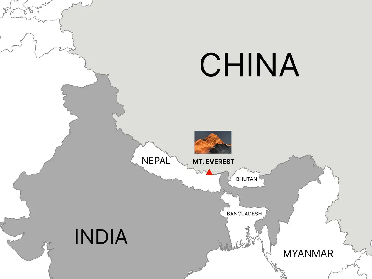
Mount Everest, which is the tallest peak in the world, can be found in the Himalayas, which are a mountain range that spans the borders of Nepal and Tibet. This legendary mountain, which reaches an astounding height of 8,848 meters (29,029 feet), presents mountaineers with a breathtaking challenge and captivates adventurers and nature fans alike with its compelling attractiveness. The awe-inspiring setting of Mount Everest is home to a remarkable combination of natural beauty, cultural history, and climbing accomplishments that are unmatched in the world.
All people are well aware of Everest’s splendour. To be more specific, the question that has to be asked is, “Where exactly is Mount Everest located?” A significant number of people are still unaware of the precise location of this breathtaking mountain panorama.
To put it another way, Mount Everest can be found in the
Between Nepal and Tibet is where you’ll find Mount Everest. At a height of 8,848.86 meters (29,032 ft), it claims the title of being the tallest structure on the planet. The land was given the name Everest in honor of George Everest, who served as a Surveyor General in India during the 19th century.
The position of Everest is a source of concern for those individuals who fantasize about experiencing the enchantment of Everest through outdoor activities such as trekking or climbing to the summit of the mountain. This essay was written with the intention of shedding light on the precise location of Everest. After reading this post, we are confident that you will have a better understanding of the country in which Mount Everest is located, in addition to other information.
Have you ever fantasized about going to Mount Everest Base Camp or Kalapatthar for the first time and following in your footsteps? You no longer need to dream since we are here to help you turn your desire into a reality. Reserve your spot right away!
Mount Everest Location and Coordinates
Mount Everest, which is the highest peak on Earth, is located on the boundary between Nepal and Tibet, which is an area of China that represents the autonomous region of Tibet.
It is roughly 27.9881 degrees north latitude and 86.9250 degrees east longitude. These are the exact coordinates. The mountain range known as the Himalayas is a large mountain system that spans across five countries: Bhutan, India, Nepal, China, and Pakistan. Mount Everest is a component of the Mahalangur section of this mountain range.
Mount Everest Location in Map
Mount Everest may be found inside Nepal’s borders in the Khumbu Pasang Lhambu Rural Municipality, which is located in the Solukhumbu District. This district is located inside the Koshi Province, Nepal’s administrative division.
Tingri County, which is located in the Xigazê Prefecture of the Tibet Autonomous Region, is where Mount Everest may be found within China.
The spectacular panoramic vistas that extend across the enormous Himalayan region are made possible by its strategic location.
 Mount Everest Location on the world map: Interactive Goole Map
 Mount Everest Location on the world map: Interactive Goole Map
Below is a detailed interactive map from google showing the exact location of Mount Everest, the surrounding peaks and respective countries surrounding this mountain.
Where is Everest located in the Himalayan Ranges?
The Himalayan range of Asia, also known as the Higher Himalayas or the Great Himalayan Range, is comprised of some of the highest Himalayan peaks and serves as a barrier between the Tibetan Plateau and the plains of the Indian subcontinent. Nepal, Bhutan, China, Bhutan, Pakistan, Afghanistan, and India are the six countries that are encompassed by the Himalayan range, which extends southwestward.
Mount Everest is the tallest peak in the Himalayas, located between Nepal and China. The China National Surveying and Mapping Administration carried out a 2005 survey to determine its precise location: 27 degrees 59 minutes north latitude and 86 degrees 55 minutes east longitude.
Where is Mount Everest Located in Nepal?
Within the Mahalangur Range of the Tibetan Plateau, which is sometimes referred to as Qing Zang Gaoyuan, Mount Everest can be found. The enormous mountain that is Everest can be found in Nepal’s Sagarmatha National Park, which is located in the Solukhumbu district. It is possible to reach Mount Everest from both the Nepalese and Tibetan sides of the mountain. On the other hand, the Nepalese sides of Everest are easier to approach.
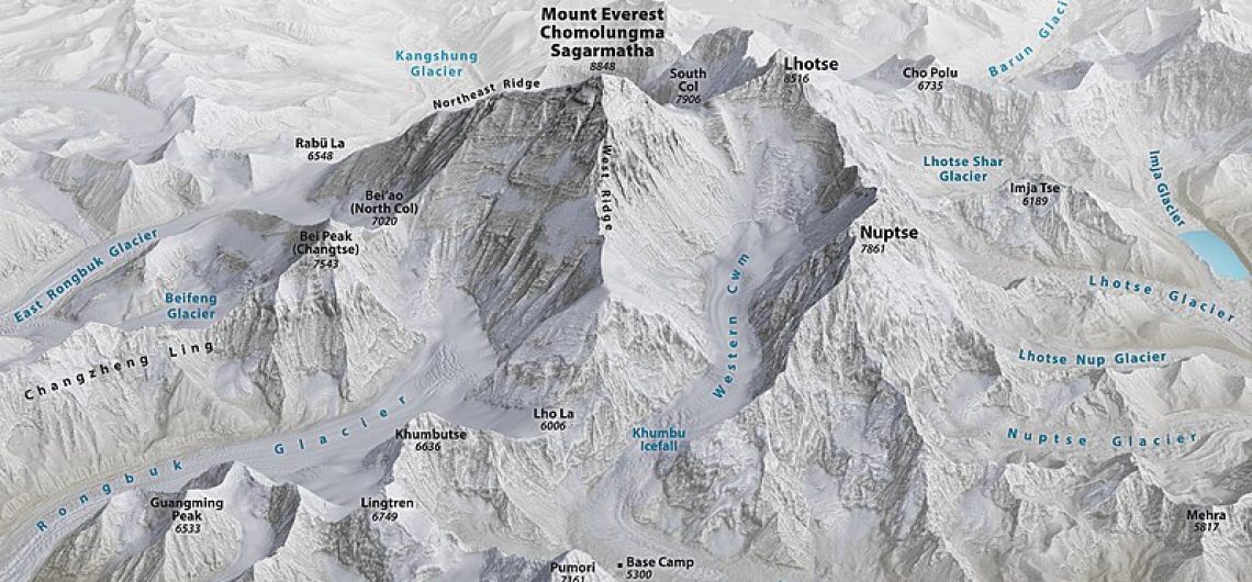
Mountain Peaks Surrounding Everest
Mount Everest, which dominates the Himalayan range, is not the only mountain in the Himalayas with a breathtaking environment; several other challenging peaks have as well. From the south, there is Lhotse, the fourth highest peak in the world, which is connected to Everest by the South Col summit.
Within the Everest Massif, the towering Makalu is to the southeast and is an essential component of the mountain range.
When we turn our attention to the west, the prominent Cho Oyu, the sixth tallest mountain in the world, appears on the horizon.
These adjacent giants, together referred to as the Everest Massif, significantly contribute to the breathtaking panorama that climbers encounter on their long ascent to the top of Everest.
The best place to view Mount Everest
Kala Patthar is a one-of-a-kind vantage point that provides a beautiful view of the Everest summit for those individuals who may not be able to undertake the difficult climb to the peak of Everest.
Kala Patthar, located on the Nepalese side of the mountain and close to Everest Base Camp, offers a breathtaking view of the tallest peak in the world. The mountain, at an elevation of 5,545 meters (18,192 feet), is a well-known destination for hiking because it provides visitors and trekkers with a spectacular, up-close view of Everest and the peaks in the surrounding area.
Individuals are able to experience the harsh grandeur of the Himalayan region while on the walk to Kala Patthar, which not only offers a visual feast of Everest but also provides opportunity to see the mountain. The path that leads to this viewpoint is characterized by prayer flags, rocky pathways, and the ever-present silhouette of Everest that serves as a guide.
How to get to Mount Evarest
Accessing Mount Everest is not a simple endeavor, and it calls for meticulous planning and preparation in order to be successful. One of the most usual ways to get to the base camp is to travel into Kathmandu, the capital city of Nepal, and then take a domestic aircraft to Lukla, a tiny town in the Khumbu region. Trekkers must hike for around eight to nine days, beginning in Lukla, in order to reach the base camp. They will pass through picturesque scenery and charming Sherpa settlements along the way.
Anyone interested in climbing Mount Everest must participate in a well-organized expedition led by knowledgeable and experienced guides. These firms are responsible for supplying climbers with all of the essential equipment, food, and assistance throughout their trek. Certified medical specialists on staff are also available to provide assistance in the event of any crises.
Before attempting to reach Mount Everest’s summit, climbers must go through intense physical training and be in outstanding physical condition. Additionally, it is required that you have previous experience climbing at high altitudes and that you have a strong command of technical mountaineering skills.
Once they arrive at base camp, climbers begin their journey towards the summit. Each camp provides climbers with a somewhat comfortable location to rest and assimilate before continuing their ascent. The weather conditions, the climber’s speed and endurance, and the time it takes to complete the ascent might range from six to eight weeks.
In the grand scheme of things, climbing Mount Everest demands not only the physical adventure itself but also the mental and emotional fortitude to accomplish it. This voyage continues to be one of the most sought-after experiences in the world, and it is a monument to the human race’s strength, tenacity, and determination.
An Account of the Trip to Mount Everest
It is not for those who are easily discouraged to undertake the route that leads to the summit of Mount Everest. Having tremendous physical strength, mental fortitude, and unwavering determination are all necessary components. It is well known that the mountain itself is notorious for its hazardous conditions, which include weather that is difficult to anticipate, terrain that is steep and rocky, and oxygen levels that are low enough to be potentially fatal. When it comes to human endurance and determination, this is without a doubt the ultimate test.
Over the course of several centuries, the Sherpa people have held Mount Everest in the highest regard as a sacred location and have a profound reverence for its power. They refer to it as “Chomolungma,” which literally translates to “Mother Goddess of the Earth.” The mountain is a source of spiritual and cultural identity for them, and they act as guides and porters for climbers who are seeking to reach the peak of the mountain.
Which country owns Mount Everest?
Mount Everest is located on the border between Nepal and China. Therefore, it is jointly owned by both countries. Mount Everest is part of the Himalayas, a mountain range that straddles the border of Nepal and China.
Which is easier to get to Between Mount Everest and Kilimanjaro?
Comparatively speaking, Kilimanjaro is considered to be more accessible than Mount Everest. The base camp of Kilimanjaro is situated at an elevation of 5,364 meters, while the peak of the mountain, known as Uhuru Peak, is situated at a height of 5,895 meters as well. When compared to the base camp of Mount Everest, which is located at an elevation of 5,380 meters and the summit is located at 8,848 meters, this makes it more accessible to the majority of climbers climbing the mountain.
Additionally, anyone with a moderate level of physical fitness can climb Kilimanjaro without needing any specific mountaineering expertise. Mount Everest, on the other hand, is a mountain that requires more advanced climbing abilities and experience, which makes it a more difficult and time-consuming expedition to complete.
When it comes to logistics, Kilimanjaro is also more accessible than other mountains. It is situated in Tanzania, a country that has a well-established tourism industry and a number of airports that provide access to the mountain. On the other hand, Mount Everest is situated in a remote and difficult region of the Himalayas, and it is necessary to travel a considerable distance and endure a rigorous journey in order to reach its base camp.
In general, Kilimanjaro is often believed to be easier to access and climb in comparison to Mount Everest. This is despite the fact that both mountains offer experiences that are both distinct and hard.
Different Climbing Routes on Mount Everest
Beginning the ascent of Mount Everest is a tough endeavour, and climbers are required to navigate through a variety of routes, each of which presents its own unique mix of challenges and opportunities for reward. Both the South Col Route, which can be reached from Nepal, and the North Col Route, which can be reached from Tibet, are considered to be the two principal routes. See Mount Kilimanjaro Routes too here.
South Col Route
Before reaching the South Col, climbers must first pass the Khumbu Icefall, then navigate the Western Cwm, and finally ascend the Lhotse Face. All of these challenges begin in Nepal. Making the final push from the South Col involves climbing the southeast ridge to reach the top of the mountain. With the world-famous Base Camp located on the Nepalese side of the border, this route is the one that is most frequently chosen.
North Col Route
A traversal of the Rongbuk Glacier, a traversal of the North Col, and an ascent of the North Face are all components of the Tibetan approach. After there, climbers make their way up the Northeast Ridge in order to reach the peak. When compared to its southern counterpart, the North Col Route presents and presents a distinct set of challenges and offers a different perspective.
Distance form Nepal and Tibet to Everest
Distance from Nepal to Mount Everest:
- Mount Everest is situated in the Mahalangur Himal sub-range of the Himalayas in Nepal.
- The distance from Nepal’s capital city, Kathmandu, to Mount Everest Base Camp, is approximately 130 kilometres (81 miles) as the crow flies.
- However, trekking to Everest Base Camp typically involves covering a distance of around 130 kilometres (80 miles) on foot over a period of 9 to 12 days, depending on the chosen route and itinerary.
- The trekking route to Everest Base Camp starts from Lukla, accessible by a short flight from Kathmandu. From Lukla, trekkers hike through various villages, including Namche Bazaar, Tengboche, Dingboche, and Lobuche, before reaching Everest Base Camp.
Distance from the Tibet Autonomous Region of China to Mount Everest:
- Mount Everest is also accessible from the Tibetan side, known as the North Face or the Tibet Base Camp.
- The distance from Lhasa, the capital of the Tibet Autonomous Region, to Mount Everest Base Camp on the Tibetan side is approximately 800 kilometres (500 miles) by road.
- The journey from Lhasa to Mount Everest Base Camp typically takes around 2 to 3 days by road, passing through towns and villages such as Shigatse and Tingri.
- Unlike the trekking route from Nepal, which involves several days of hiking, reaching Everest Base Camp on the Tibetan side is primarily done by vehicle, as the base camp is accessible by a paved road that leads directly to the mountain’s northern face.
- However, travelers still need to acclimatize to the high altitude, as the elevation at Everest Base Camp on the Tibetan side is over 5,000 meters (16,400 feet) above sea level.
Related articles:
- Where is Mount Kenya located?
- Where is Mount Meru located?
- Where is Rwenzori located?
- Where is Ol Doinyo Lengai located
![]()