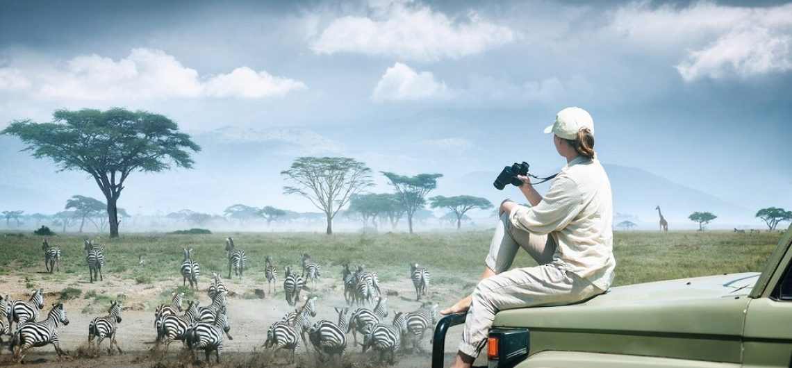
Our Serengeti map might not show every tiny detail of the Serengeti National Park, but we have done our best to show a few popular accommodation options in the park, the major and frequently used airstrips dotted around the park, some attractions, landforms and waterbodies found in the vast Serengeti ecosystem. The Serengeti covers a huge chunk of remote land measuring about 14,750 square kilometres in total, something that the map below does not do justice to, but worry not, we have also included an interactive Google map in the end.
The Serengeti itself is divided into five distinct regions, each with its own personality, landscape, and wildlife drama, just like any other geographical place comprising the north, the south, the west, the east and the central. When it comes to safaris, only three parts are of significance in terms of vegetation and geography: the Serengeti Plains (south/central), the Western Corridor, and the Northern Serengeti.
Map of the Serengeti National Park
Below is a detailed map of the Serengeti National Park showing all the locations, some attractions and accommodation properties found in the Serengeti.
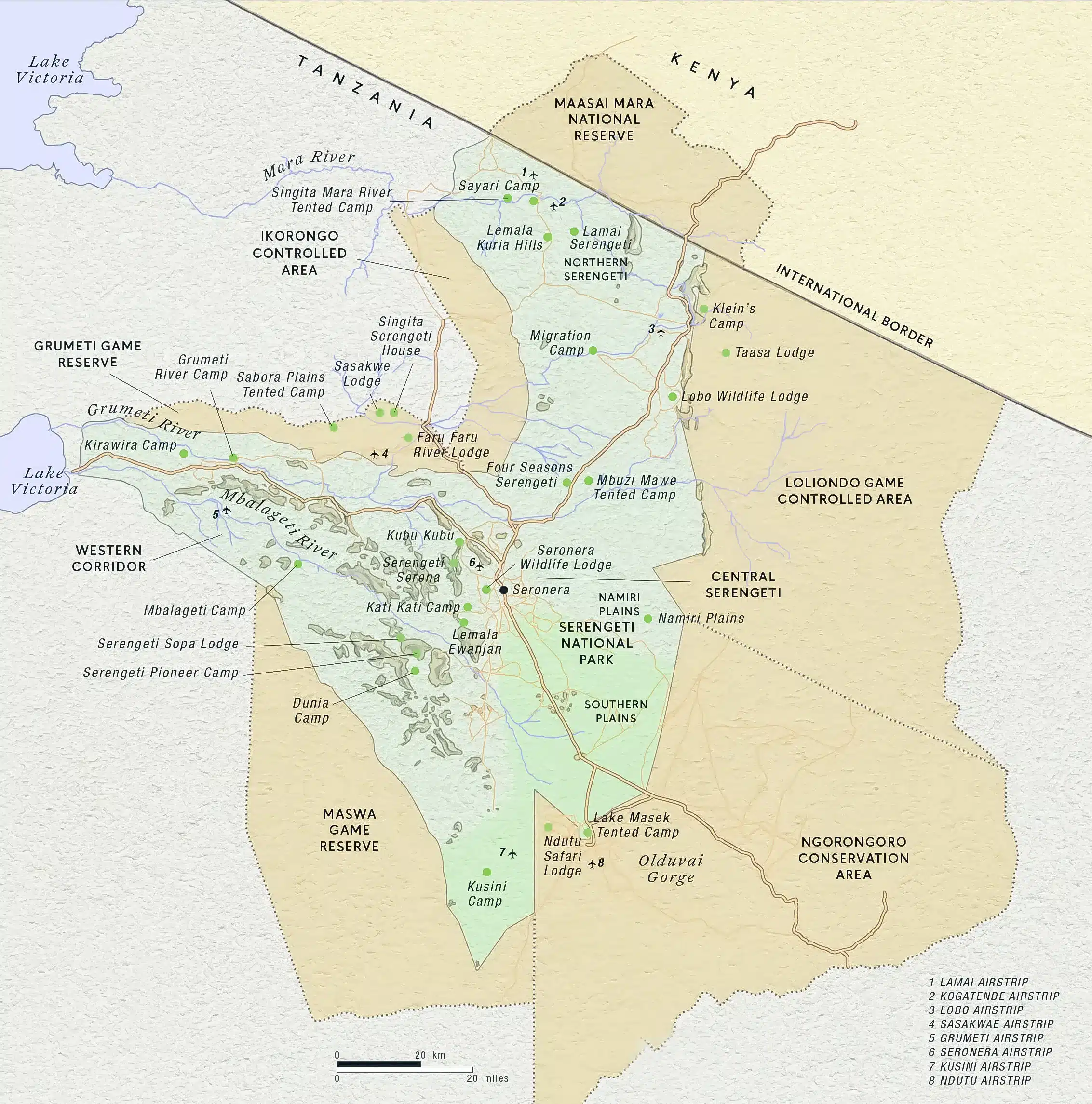 Some interpretations further break these down to include the Eastern Serengeti, totalling four sections.
Serengeti Plains (South/Central): Characterised by vast, treeless grasslands (Seronera Valley) and kopjes, this area is known for the wildebeest breeding season.
Western Corridor: Marked by the Grumeti River and dense forests/bush, it is famous for river crossings from May to July.
Northern Serengeti: Dominated by open woodlands and rolling hills, it is known for the Mara River crossings and is less visited because it comes alive when the wildebeest and other animals cross over to the other side of the river and vice versa.
Southern Serengeti – Bordering Ndutu
This is where the story begins every year. Vast open short-grass plains stretch as far as the eye can see, dotted with the occasional acacia and the famous kopjes (granite rock outcrops). From December to March this area becomes one giant maternity ward — the calving season turns the plains into a sea of tiny wildebeest calves learning to run within minutes of birth. Predators are everywhere (lions, cheetahs, hyenas), but the sheer numbers are staggering. If you want raw, emotional wildlife action with newborn drama, this is your spot.
Central Serengeti – Seronera
Seronera Valley and the surrounding area are the Serengeti’s reliable core. Open grasslands, acacia woodlands, and plenty of kopjes create perfect hunting grounds for big cats. This region has excellent wildlife viewing even outside migration season because resident herds of zebra, giraffe, elephant, and topi stay here all year. When the migration passes through (April–May and November–December), the central area becomes a massive wildlife highway — perfect for those who want consistent game viewing plus the chance to see the herds on the move.
Western Serengeti – The Grumeti
The Western Corridor is all about drama at the Grumeti and Mbalageti rivers. Dense woodlands, permanent water, and the famous Grumeti River create a natural bottleneck. In May–June the herds pile up here before tackling the first serious river crossing — crocs waiting in the pools make it tense but not quite as chaotic as the Mara River further north. This area also has some of the best resident cheetah and leopard populations and feels wonderfully remote.
Northern Serengeti – Kogatende and Lamai triangle
This is the wild north — rolling hills, thick bush, and the mighty Mara River forming the border with Kenya. From July to September, the migration reaches its legendary climax here. Thousands upon thousands of wildebeest and zebra plunge into the crocodile-infested waters in scenes that have been called “the greatest show on earth.” The landscape is more rugged, the crowds thinner than in the south, and the big-cat action (especially lions) is outstanding even when the herds move on.
Eastern Serengeti – Loliondo Area
Often overlooked but absolutely magical, the eastern side (sometimes called the “Serengeti Plains Extension” or Loliondo area) offers open savannah, dramatic kopjes, and far fewer vehicles. It’s a favourite for walking safaris and those who want the Serengeti experience without the peak-season buzz. The migration brushes through here in October–November on the way south, but even outside that window, you’ll find resident wildlife and a true sense of wilderness.
 The Great Wildebeest Migration Map
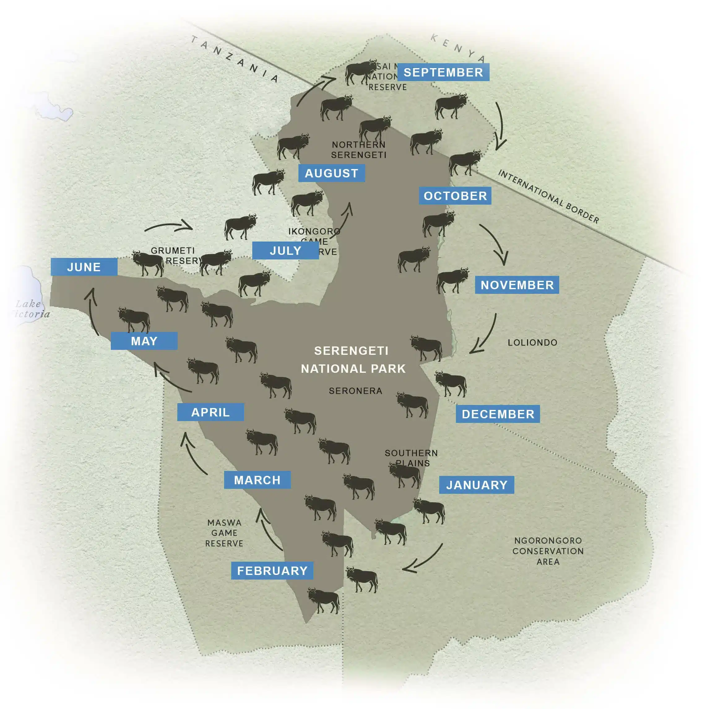
A map of the great wildebeest migration would help you see the movement of the wild animals in the Serengeti Ecosystem from location to location and at what time of the year.m If there’s one thing every safari lover wants to understand before heading to Tanzania, it’s exactly where those millions of wildebeest are at any given moment. The Great Migration isn’t a straight line — it’s a living, breathing, 1,500-mile loop that circles through the Serengeti ecosystem, driven entirely by the rains. A good migration map is your secret weapon: it shows you why certain areas explode with life in specific months and helps you plan a trip that actually puts you in the right place at the right time. The route starts in Tanzania’s Ngorongoro Conservation Area, sweeps north through the Serengeti, crosses into Kenya’s Maasai Mara, and then loops back south. Because rainfall patterns have become less predictable lately, the “classic” calendar is only a rough guide — that’s why experienced travellers always build in extra time on safari. The two absolute highlights most people dream about? The heart-stopping Mara River crossings (usually late July to early September) and the calving season in the southern plains (late December to mid-March), when up to 8,000 calves are born every single day.
Monthly Tracking of the Wildebeest Movement Using Our Map
As the map illustrates, we can get a clear picture of how to track and estimate the timing of the wildebeest migration in the Serengeti. Note that the wildebeest migration event doesn’t happen in the Serengeti alone. It extends to the Ndutu, Serengeti-Ngorongoro border, which is also part of the greater Serengeti Ecosystem.
January
The herds spread out across the short-grass plains of the southern Serengeti, around Ndutu and right up into the northern part of the Ngorongoro Conservation Area. By the end of the month, the calving season kicks off in earnest — around 8,000 wildebeest calves are born every single day. With thousands of wobbly newborns on the ground, predators are everywhere, and the adults form protective circles that create some of the most intense wildlife scenes you’ll ever witness.
February
Calving is still in full swing. You’ll see mother wildebeest forming living barricades around their young to fend off lions, hyenas, and cheetahs. Baby wildebeest are on their feet within minutes of birth, while nearby lion cubs get their first hunting lessons. It’s non-stop drama, wonder, and pure Africa at its most emotional.
March
The herds remain scattered across the southern plains, polishing off the last of the fresh grass while the final calves arrive. Slowly they begin to bunch up, ready for the long journey north.
April
The northward movement starts in earnest. Early groups are already pushing into the central and western Serengeti, following the rains in search of fresh grazing.
May
The massive herds funnel into the central and western regions. Around Moru Kopjes and western Seronera you can see hundreds of thousands of animals — wildebeest joined by huge numbers of zebra plus Thomson’s and Grant’s gazelle. The plains come alive with dust and movement.
June
The migration slows as the herds reach the south side of the Grumeti River. They gather in the Western Corridor, building up for the first river crossings through a series of pools and channels. Crocodiles lurk, but because the water isn’t one continuous deep river, the drama is slightly less intense than what’s coming further north.
July
Most herds are now scattered through the Grumeti Reserve, Ikorongo, and the heart of the park. By the end of the month the real spectacle begins — the Mara River crossings. Animals plunge into the brown water while massive Nile crocodiles and hippos wait below. This is the “World Cup of Wildlife” — raw, loud, and unforgettable.
August
The river crossings continue at full throttle. Millions of wildebeest, zebra, gazelle, and even a few kudu surge across into Kenya’s Maasai Mara Game Reserve in scenes of pure chaos and survival.
September
The survivors spread out across the northern Serengeti plains and the lush grasslands of the Maasai Mara. Depending on the rains, some late crossings can still happen into the first weeks of the month.
October
Large herds dominate the Maasai Mara. Some groups only stay a few days before starting the journey south again.
November
The short rains begin, and the herds turn south, streaming back through western Loliondo and the Lobo area of the Serengeti, heading toward the fertile southern plains once more.
December
The herds cluster in the northeastern and southern regions, spreading out across the plains to feast on the new green growth. The cycle is about to restart — calving is just around the corner.
Serengeti-Ndutu, Wildebeest migration Safaris
Whether you’re planning your first safari or your tenth, having this migration map in your head (or on your phone) completely changes the game. It lets you choose the right region, the right camp, and the right month so you don’t just see the Serengeti — you experience the greatest wildlife spectacle on the planet exactly when it’s at its best.Safe travels, and may your map lead you straight into the heart of the action!
- 16 Days Wildebeest migration safari, Kilimanjaro trek and Zanzibar
- 6 Day Wildebeest Calving season & Migration Safari in Ndutu – Serengeti
- 7-Day Great Wildebeest Migration Safari in the Western & Central Serengeti
- 10 days Mara river crossing & Great Wildebeest migration, Serengeti safari
- 9 Days Wildebeest Migration Crossing, August to October
- 8 Days Ndutu & Wildebeest Calving Season Safari
- 7 Days Masai Mara & Serengeti Wildebeest Crossing Safari
- 3 days Serengeti Safari
- 7 days Tanzania Fly-in Tarangire, Serengeti, Ngorongoro Luxury Safari + Optional Balloon Safari
Google Maps for Mobile Camps That Track the Serengeti Wildebeest Migration
One of the smartest ways to follow the herds is to stay in mobile tented camps that actually move with the migration. As shown in the interactive google maps of the Serengeti national park, most properties reposition their camps every few weeks, so you’re always in the thick of it. Their maps show seasonal locations: southern camps in January–March for calving, western in May–June, northern in July–September, and so on. These camps give you front-row seats without the long daily drives — pure magic if you want to be where the action is. See map of the accommodation options in Serengeti here.
![]()