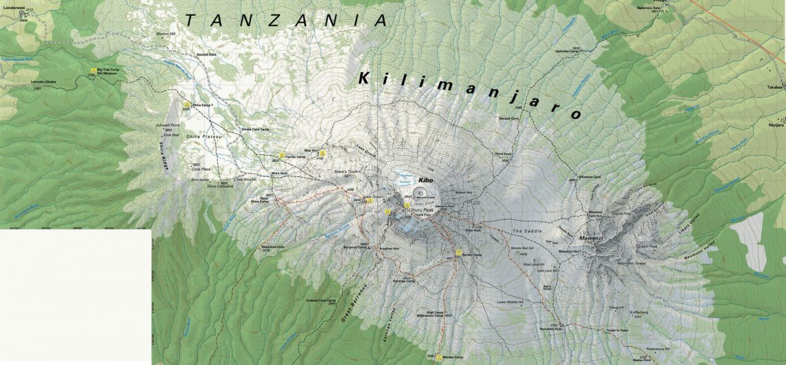
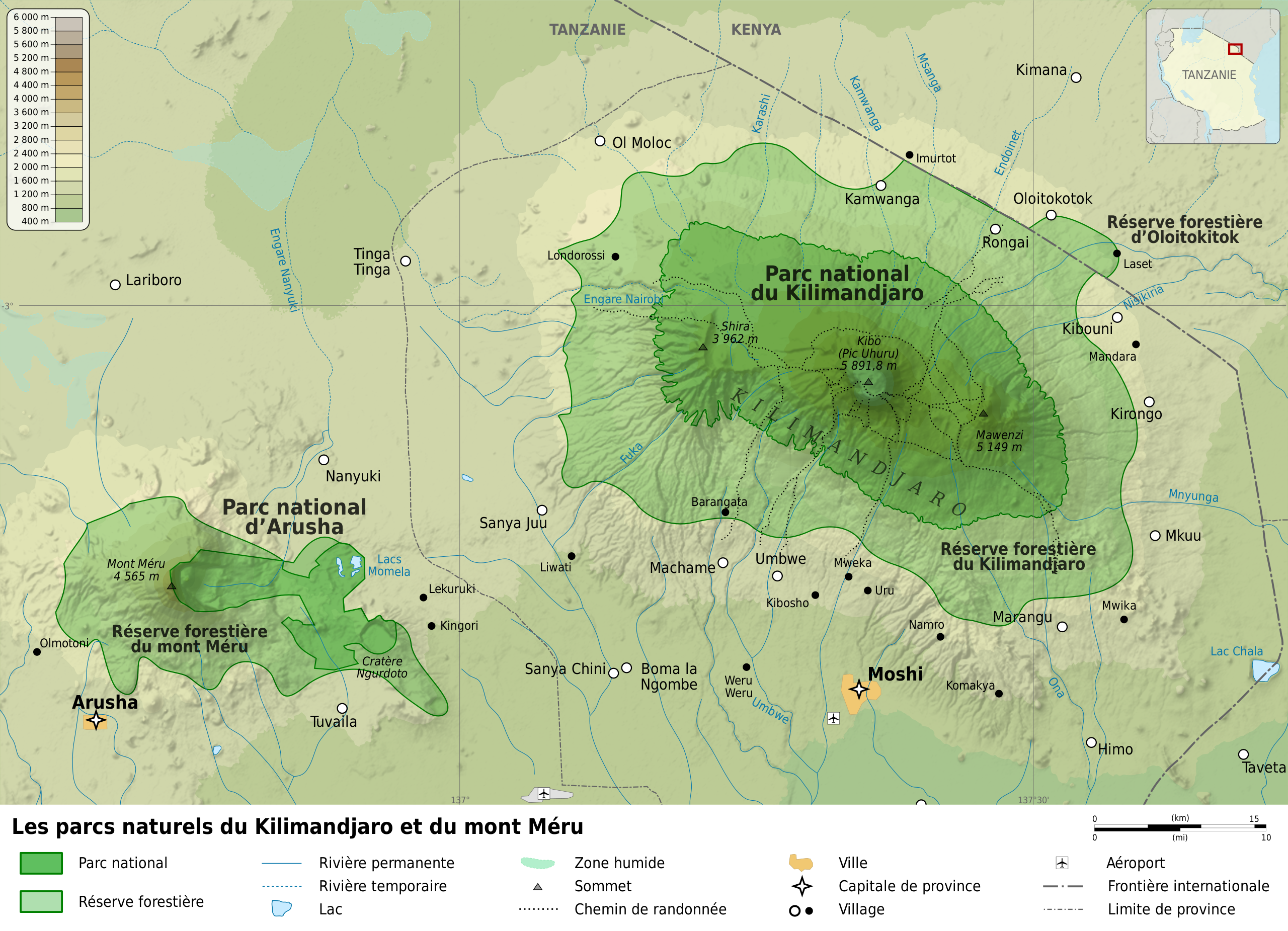
On the map, Mount Kilimanjaro is located close to the Kenyan border in northeastern Tanzania. The mountain’s highest peak is Kibo, the central cone, which rises to 19,340 feet (5,895 meters) tall making it the highest mountain in the entire African continent. Kilimanjaro is located approximately 140 miles (225 km) south of Nairobi, Kenya, and roughly 100 miles (160 km) east of the East African Rift System. The massif, which roughly spans 50 miles (80 km) from east to west, is made up of the three main extinct volcanoes Kibo (in the center), Mawenzi (to the east), and Shira (to the west) (west). The distance from the equator to Mount Kilimanjaro is just a mere 200 miles or 325 km.
The youngest and highest peak, Kibo, has the shape of a typical volcanic cone and crater and is connected to Mawenzi (16,893 feet [5,149 meters]), the older core of a former summit, by a 7-mile (11-km) saddle at an altitude of roughly 15,000 feet (4,500 meters). Shira Ridge, which rises to a height of 13,000 feet (3,962 meters), is a crater remnant. Kilimanjaro dips down to the plains below, which are located at an elevation of around 3,300 feet, in a characteristic volcanic curve below the saddle (1,000 metres).
Mount Kilimanjaro Location and Geographic Coordinates
Geographical coordinates: 3.0674° S, 37.3556° E
Geographical location: Handeni, Tanga, Tanzania, Africa
Elevation: 5,895 m
Prominence: 5,885 m
Local or Alternate Name(s) Alternate: Mount Kilimanjaro
Slovenian: Kilimandžaro
German: Kimanscharo
French: Kilimandjaro
Highest Summit: Kibo-Uhuru Peak
Peak Type: Volcano
Latitude/Longitude (WGS84) 3° 4′ 35” S, 37° 21′ 15” E
-3.076448, 37.354034 (Dec Deg)
317082 E 9659816 N, Zone 37 (UTM)
Country: Tanzania (Highest Point)
State/Province: Kilimanjaro
First ascent: October 1889
Mountain range: Eastern Rift mountains
First ascenders: Ludwig Purtscheller, Hans Meyer
Google Earth Map of Kilimanjaro
Where could we be without google maps, right? Well here is an insightful map of Mount Kilimanjaro on Google Earth map. Click here to view it on google earth online or if you prefer you can download the google earth app online.
Bing and Google
Whichever map you use for Mount Kilimanjaro, they are similar on both google and bing. Please use the map above for google maps or the map below to locate Mount Kilimanjaro on Bing.
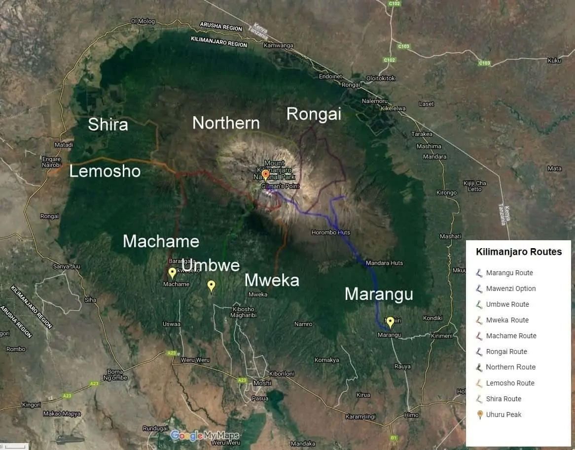
Kilimanjaro Route Maps
There are four primary routes we can take you on, as you can see from this map. These routes were chosen for their amazing scenery, geography, practicability, and safety. Regarding the number of camps, degree of difficulty, and amount of time needed to accomplish, each route offers something unique.
There are several ways to climb the peak. To increase your chances of success in reaching the top, choose the path that best suits your level of preparation, expertise, and expectations. The routes’ level of difficulty, visual appeal, and visitor volume vary greatly. Above 13,000 feet, the lower levels’ gradual slopes can turn into a 30-degree struggle (4,000 m).
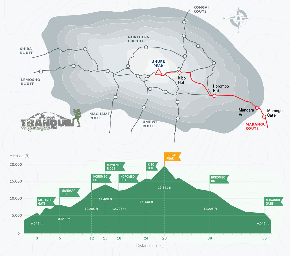
Marangu Route Map
A favorite amongst hikers on Kilimanjaro, the Marangu route starts from the southeastern side of the mountain. slopes that are simple and moderate. Gorgeous moorlands and a piece of rainforest. modest but cozy hut shelter. a wise decision during the wet season. a poor profile of acclimation. Because of the descent on the same trail, the scenery is less picturesque. 82 kilometers, 5–6 days. More about Marangu Route
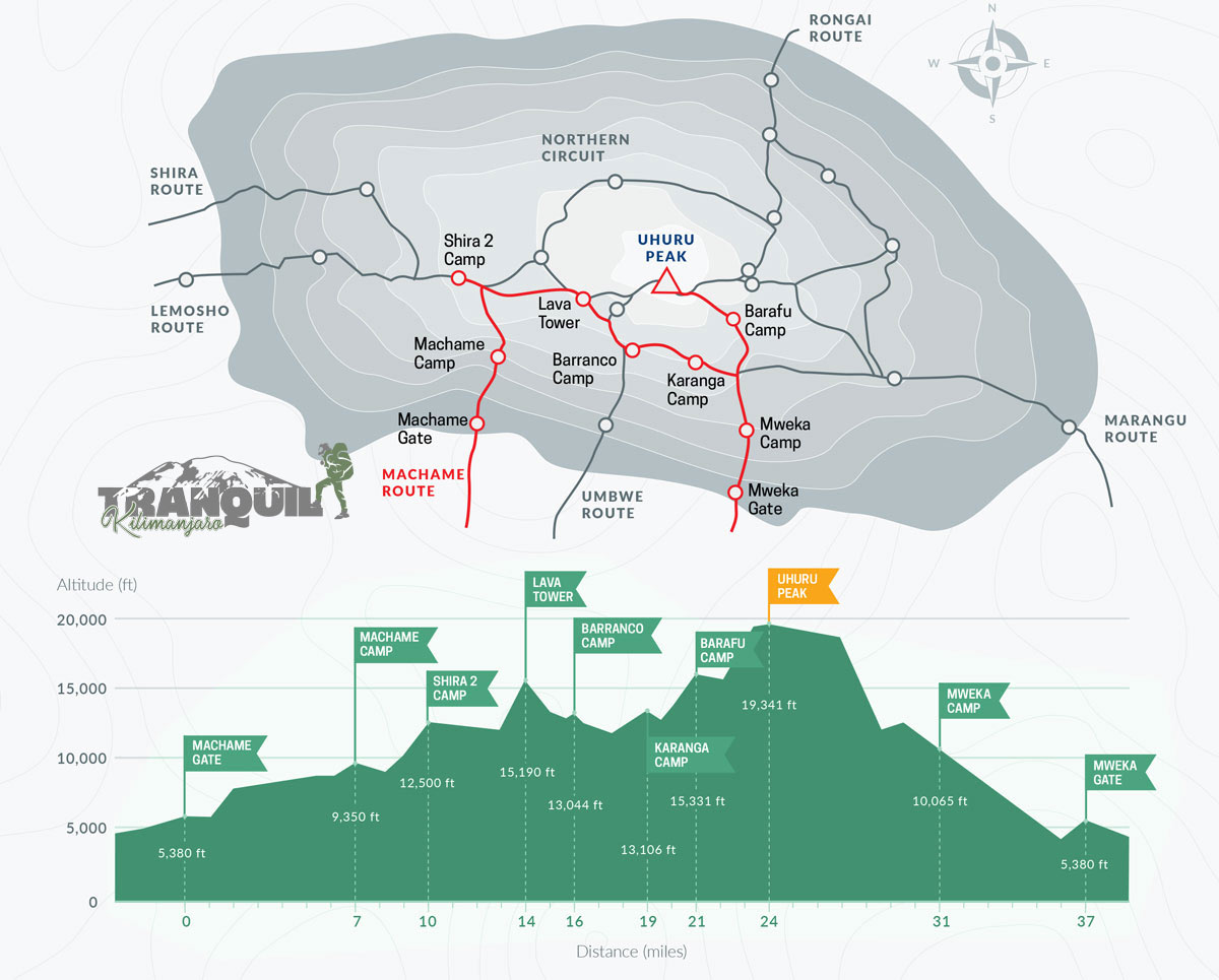
Machame Route Map
Another popular route on the mountain that is frequently used by climbers and approaches the summit from the south. Trailhead access is via a short drive. the trail includes a southern crossing that is very picturesque. The pathway up/down is challenging, but it’s excellent for acclimatization. shortest way, best. Camping. 6 to 7 days, 62 kilometers. More about Machame Route
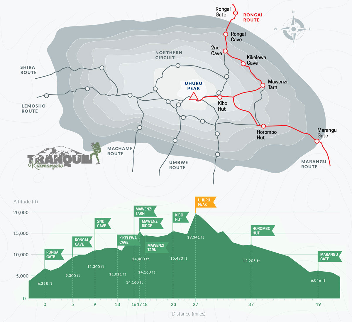
Rongai Route Map
Featuring a long drive to the trailhead, this route originates from the northern slopes. A remote and less busy. simple, mild slopes. preferred replacement for Marangu. lovely area of alpine desert. suitable for the rainy season. Camping. Good profile of acclimatization. 7–9 days for 79 kilometers. More about Rongai Route
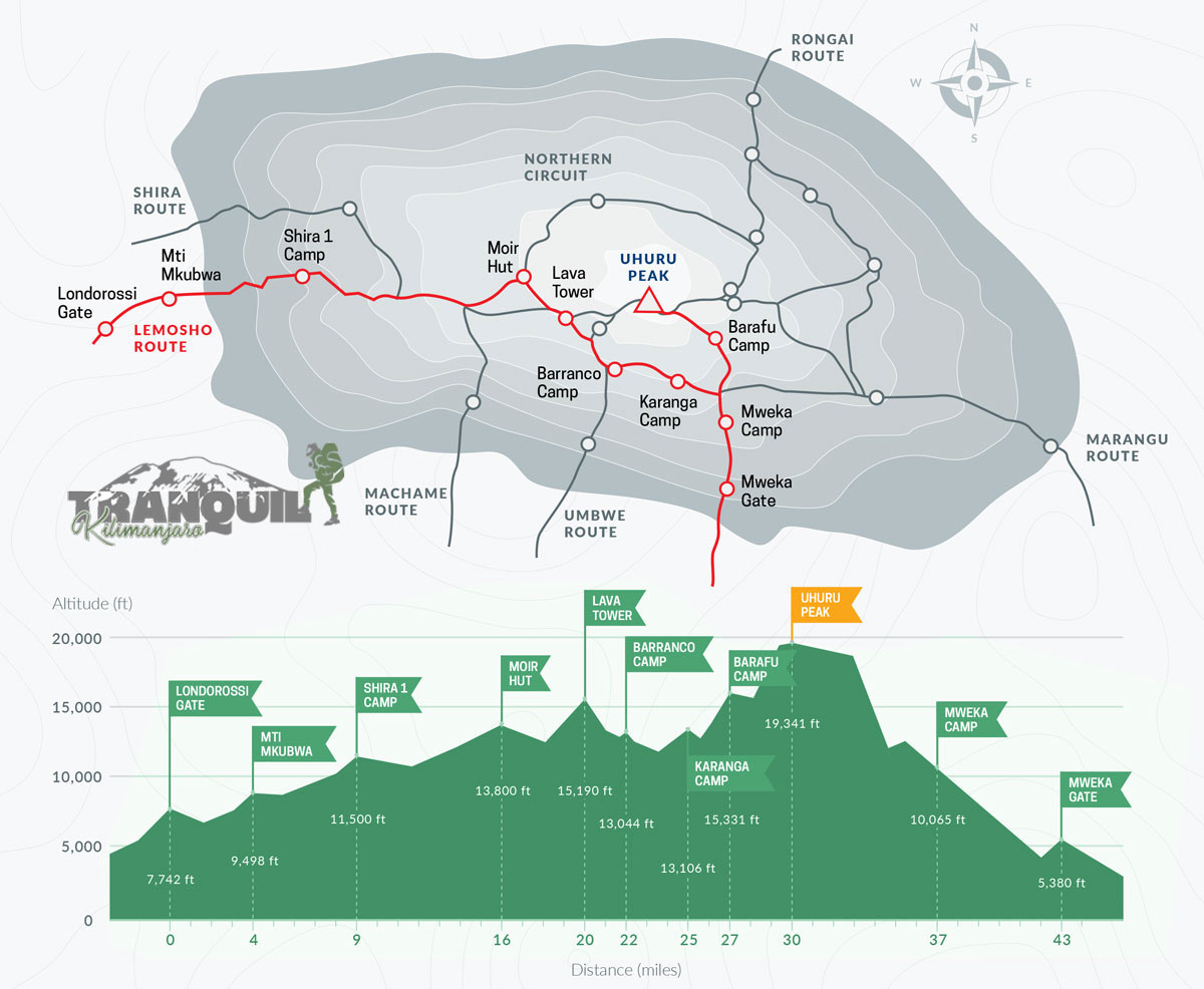
 Lemosho Route Map
 Lemosho Route Map
Another lengthy drive to the trailhead. This route approaches the summit of Kilimanjaro from the west. remote and less busy. Very scenic. with a southern crossing, quite beautiful. Camping. The pathway up and down is challenging, but it’s great for acclimatization. 70 kilometers, 6 to 8 days. More about Lemosho Route
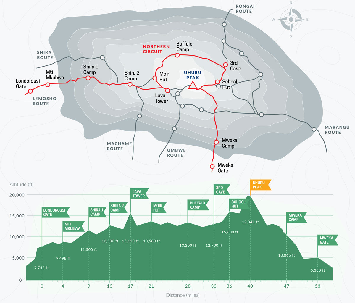
 Northern Circuit Route Map
 Northern Circuit Route Map
The latest route on Kilimanjaro. Almost no climbers on the north side. comes from the west. with a northern crossing, really beautiful. almost 360° of vistas. difficult uphill and downhill terrain at first, but fairly level in the middle. most effective path for acclimatization. greatest distance. Camping. 9 days and 98 kilometers. More about Northern Circuit.
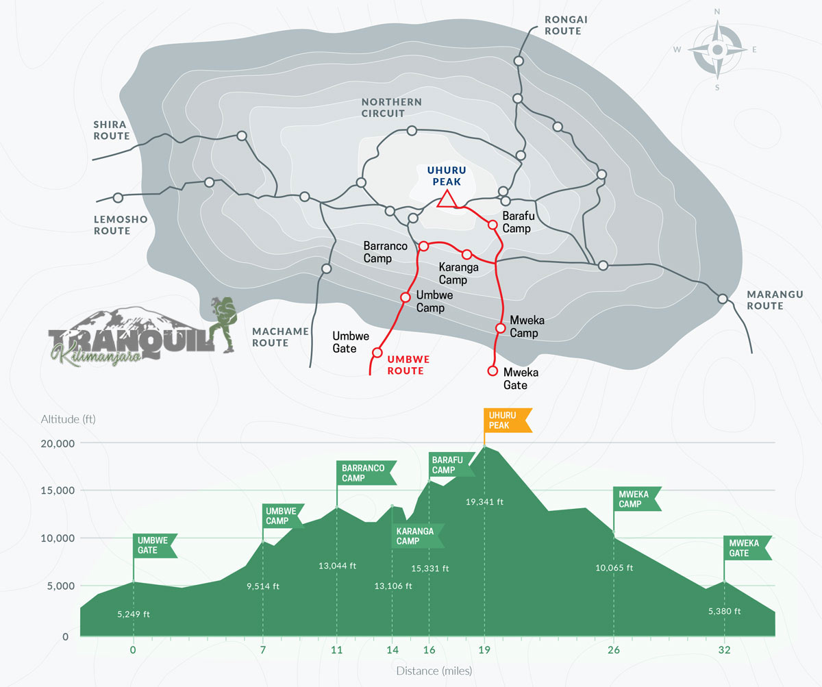
 Umbwe Route Map
 Umbwe Route Map
The least-traveled route. comes from the south. The most direct and difficult trail. magnificent ridge scenic with a traverse to the south. Poor acclimatization profile owing to difficult terrain and rapid elevation. The pre-acclimatization process is advised. Camping. 53 kilometers and 6–7 days. More about Umbwe route
 Importance of using maps for your Kilimanjaro climbs
 Importance of using maps for your Kilimanjaro climbs
When making travel arrangements, it is crucial to study maps of Mount Kilimanjaro. There are a total of seven paths, and picking the best one will influence both your success rate and how enjoyable the climb will be for you. Making the assumption that hiring a professional guide will ensure summit success is a fairly typical error. The success rates of each path vary, and some are more difficult than others. Additionally, you must be completely prepared for each step of the climb and the required acclimatization. This is why it’s crucial to properly plan your route, read a map, and navigate with ease once you’re on the road.
Each path has advantages and disadvantages, and it will adopt a different strategy while making stops at various camps. The length of your stay in Tanzania, your previous climbing and altitude-related experience, the season and weather, as well as your degree of fitness, are other considerations. Contact our staff if you’re unsure about which Kilimanjaro route is best for you. We can offer guidance and assist you in making the best travel decision.
Kilimanjaro National Park Map
It’s crucial to utilize a more precise map to navigate in addition to familiarizing yourself with a Kilimanjaro map before beginning your climb. At the entrance of Kilimanjaro National Park, certain top-notch maps are available for purchase.
If you reserve your trip via us, we’ll give you a thorough orientation the day before and assist you in organizing all of your gear and maps.
Along with helping you, our knowledgeable mountain guides will make sure everyone stays on course. As a result, you won’t have to worry about finding your way about independently. We have led several international groups throughout the years, including walking clubs, schools, university clubs, and even record-breaking individuals. We take great satisfaction in our safe acclimatization program, which has a 95% success rate on average.
Physical Maps
Because it is not permitted by the National Park, it is impossible to climb Kilimanjaro without a guide. A guide is necessary to maintain the group’s health and safety and to keep everyone on the right pace for acclimatization. Even though you will have assistance with navigation, carrying your own map is still a crucial piece of equipment for any mountain climb.
You may purchase the following maps to aid you on your journey:
- Kilimanjaro, 1:62,500, ITMB Publishing, ISBN-10: 1553415507, ISBN-13: 978-1553415503
- Kilimanjaro: Map and Guide, 1:75,000/1:30,000 West Col Productions, ISBN: 0906227666
- Kilimanjaro, 1:80,000, Climbing Map, ISBN 13: 9783952329412
- Kilimanjaro National Park, 1:125,000, Maco Editions
- Arusha National Park, 1:44,000/1:20,000, Veronica Roodt Publications
- Arusha & Mt.Meru National Park Tanzania, Harms Verlag, ISBN 13: 9783927468276
Mount Kilimanjaro Location and facts
Tanzania, where Mount Kilimanjaro is situated, is 205 miles from the equator. Kibo, Mawenzi, and Shira are the three volcanic cones that make up its three peaks. It is a dormant volcano. Kibo is the highest of the cones, and this is where the peak lies. Kibo is dormant, but Mawenzi and Shira are extinct. This implies that the Kibo cone could erupt once more. However, the most recent activity was 200,000 years ago, and the last eruption was 360,000 years ago.
The National Park is easily accessible from Nairobi or Mombasa due to its proximity to the Kenyan border. It takes just two hours to go to Kilimanjaro International Airport. Additionally, short flights are accessible from Kigali, Rwanda, and Kampala, Uganda.
Trekkers will pass across five ecological zones as they ascent Kilimanjaro. As elevation rises, the zones get drier and colder, which causes fauna to decreasing as you approach closer to the summit. When you get close to the peak, the terrain will largely be made up of ice and rock as you approach the arctic zone. Your body will be deteriorating at this extremely high altitude. The human body can tolerate brief exposures at this altitude, but prolonged stays are not feasible.
Although more than 30,000 people attempt to climb Kilimanjaro each year and it is extremely possible to reach the summit, around 50% will fail. Altitude sickness issues are virtually invariably the blame for failure.
This is why we emphasize acclimatization so much. Because of our programs’ ample time for adjustment, we consistently achieve an exceptional success rate of 95%.
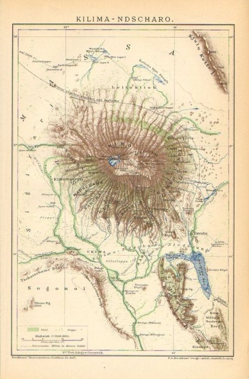
Old Map of Mount Kilimanjaro
According to Maps online, this old Kilimanjaro map was done between 1891 to 1895 by F.A. Brockhaus’ a geogr.-artist from Anstalt Germany.
![]()