Mount Williamson, towering in the Sierra Nevada mountain range of California, is renowned for its grandeur and challenges it poses to mountaineers. As the second-highest peak in the state, this mountain is an iconic landmark and a symbol of rugged wilderness.
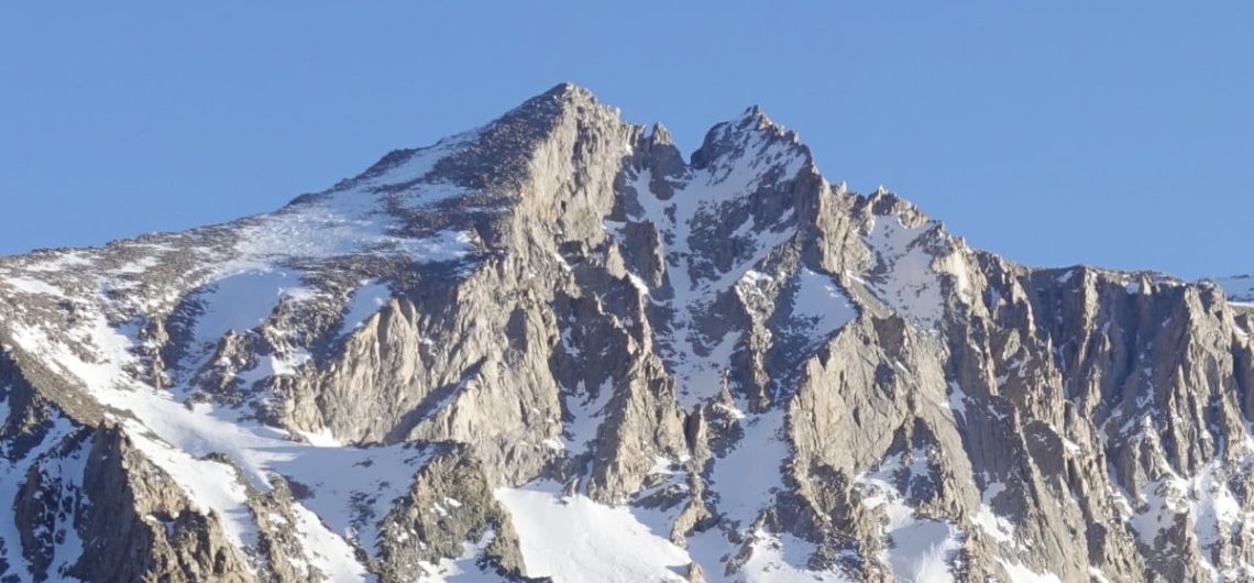
Mount Williamson is considered to be one of the prominent summits within the Sierra Nevada mountain range. The geological formation in question is undeniably remarkable, as it ascends to an impressive altitude of 9,000 feet over the Owens Valley. Its imposing presence captivates observers from considerable distances, casting a shadow over and exerting dominance over its surrounding environs. The remarkable size of this entity is only equaled by its intricate nature. Its steep surfaces are encompassed by seemingly endless, winding ridges; many valleys and narrow passages divide immense protrusions; towering spires loom over the observer…
In addition to the primary peak, which is the genuine summit, the East (14,125′) and West Horns (14,160′) of the massif also pose a significant challenge for climbers. These subpeaks may be rather intimidating for anyone attempting to ascend the mountain. While they may appear little when viewed from the top, they present a different perspective and pose a formidable obstacle when one is situated below the summit plateau. The steep declines elicit a response, either attracting or repelling individuals into the empty spaces around them, creating a feeling of vulnerability that even experienced mountaineers find daunting. The scene has resemblance to the Lord of the Rings. In order to traverse from the top of the East Horn to the summit plateau by crossing the West Horn, it is necessary to engage in 5th class climbing. It is important to note that even if rappelling is chosen as the method of descent, a high level of proficiency in navigating 5th class terrain is still essential.
The predominant method of ascending Williamson is by the conventional West Face route, which entails Class 3 climbing. The ascent itself does not present an excessive level of difficulty; rather, reaching the starting point of the ascent poses a distinct challenge. The prevailing method often entails embarking on an 11-mile journey to reach Shepherd Pass, which stands at an elevation of 12,040 feet. This is then followed by a challenging traversal of the Williamson Bowl, which has been shaped by glacial activity. Although the topographic representation of the Williamson Bowl region may initially appear rather level, it is important to note that the terrain really consists of several subtle undulations. In order to reach the base of the path, one must navigate through a series of lakes and traverse several hills adorned with big boulders.
It is imperative to acknowledge that embarking on the trek to Shepherd Pass, which stands at an elevation of 12,040 feet, is not a leisurely excursion. The elevation at the trailhead is just 6,299 feet. Furthermore, it is evident that the individuals responsible for constructing the route may have been under the influence of illicit substances, since several sections of the trail have switchbacks with an incline of around 3 feet every 100 yards. Additionally, there is a particular instance where the trail lowers almost 1000 feet instead of ascending as expected.
Key Features:
- Elevation: Mount Williamson reaches an impressive height of 14,379 feet (4,383 meters). Its prominence in the Eastern Sierra region makes it a prominent feature of the California landscape.
- Location: Situated in the Inyo National Forest, Mount Williamson is part of the California 14ers, a group of mountains exceeding 14,000 feet. It’s located in the eastern part of California, not far from the Nevada border.
Activities and Attractions:
- Mountaineering: Mount Williamson offers a demanding challenge for mountaineers. Ascending this peak involves technical climbing skills, ice and snow travel, and complex route-finding. Experienced climbers are drawn to its rugged beauty and the satisfaction of conquering a formidable 14er.
- Hiking and Backpacking: While reaching the summit of Mount Williamson is a feat reserved for seasoned mountaineers, hikers and backpackers can explore the surrounding area. There are various trails in the Eastern Sierra that offer stunning views of the mountain, including the Pacific Crest Trail (PCT) and the John Muir Trail (JMT).
- Scenic Beauty: The Eastern Sierra region boasts breathtaking landscapes. The proximity to Mount Whitney, California’s highest peak, makes this area a hub for nature enthusiasts. You’ll find pristine lakes, alpine meadows, and rugged canyons that are perfect for photography and wildlife observation.
- Wildlife Viewing: The region around Mount Williamson is home to diverse wildlife, including marmots, bighorn sheep, golden eagles, and more. Observing these creatures in their natural habitat is a delight for nature lovers and photographers.
How to Get There:
- To reach Mount Williamson, travelers can start in the nearby town of Independence, California, which is the gateway to the Eastern Sierra. The approach to the mountain depends on the specific trail or route chosen.
Mount Williamson Trekking Itinerary
Mount Williamson, with its imposing presence and the challenges it presents to climbers, is a captivating natural wonder in the Sierra Nevada. It offers an unforgettable experience for mountaineers and hikers alike, with its rugged beauty, alpine terrain, and stunning vistas. Whether you’re standing at its base, gazing at it from a distance, or daring to ascend its slopes, Mount Williamson embodies the spirit of adventure and the allure of California’s pristine wilderness. It is an ideal destination for those seeking to immerse themselves in the grandeur of the Eastern Sierra.
Climbing Mount Williamson, located in the Sierra Nevada mountain range in California, is a challenging and rewarding endeavor. Here’s a sample itinerary for a climbing expedition to Mount Williamson:
Day 1: Arrival and Preparation
- Arrive at the town of Independence, California, which serves as the base for climbing Mount Williamson.
- Check in with the Eastern Sierra Visitor Center to obtain any necessary permits and get updated on current trail and weather conditions.
- Arrange for transportation to the trailhead, typically via Shepherd Pass Trail.
Day 2: Begin the Hike
- Start the hike early from the Shepherd Pass Trailhead. The trailhead is located at high elevation, so be prepared for altitude changes.
- Hike through scenic canyons and forested areas, gradually gaining elevation.
- Reach Anvil Camp, set up camp, and spend the night acclimatizing to the higher altitude.
Day 3: Ascend to Mahogany Flat
- Continue the hike toward Mahogany Flat, where you’ll establish your high camp. The route becomes steeper as you approach the flat.
- Set up camp at Mahogany Flat and rest for the summit day.
- Spend the afternoon reviewing gear, practicing climbing skills, and checking weather forecasts.
Day 4: Summit Day
- Begin the summit push in the early hours to take advantage of the firm snow conditions and avoid afternoon storms.
- Ascend Mount Williamson, which involves technical rock and snow climbing, including sections of Class 3 and 4 terrain.
- Reach the summit and enjoy panoramic views of the Sierra Nevada range.
- Descend safely to Mahogany Flat, where you’ll spend the night.
Day 5: Descend and Return
- After breakfast, break down camp and start the descent back to Anvil Camp.
- Continue descending the Shepherd Pass Trail and return to the trailhead.
- Celebrate the successful climb and plan your journey back to Independence or other accommodations.
Please note that climbing Mount Williamson is a challenging and technical ascent, and it should only be attempted by experienced climbers with appropriate skills and equipment. Additionally, the Eastern Sierra region can experience rapidly changing weather conditions, so always check forecasts and be prepared for adverse weather. This is a general itinerary, and actual details may vary based on route choice, weather conditions, and the experience level of your climbing team. Prioritize safety and environmental responsibility throughout your expedition.
Mount Williamson vs Kilimanjaro comparison
Mount Williamson and Mount Kilimanjaro are two distinctly different mountains, each offering unique mountaineering experiences. Let’s compare these two peaks in various aspects:
Mount Williamson:
Location:
- Mount Williamson is situated in the Sierra Nevada mountain range in California, United States.
- It’s a prominent peak in the Eastern Sierra region, known for its remote and rugged terrain.
Height:
- Mount Williamson stands at an elevation of 14,379 feet (4,383 meters) above sea level.
Climbing Difficulty:
- Climbing Mount Williamson is considered challenging and technical.
- The ascent involves technical rock and snow climbing, including Class 3 and 4 terrain, and it requires advanced mountaineering skills.
Environment:
- The climb to Mount Williamson takes place in the stunning, high-alpine terrain of the Sierra Nevada.
- The region features steep slopes, rocky ridges, and glaciers, and it offers a mix of snow and rock features.
Significance:
- Mount Williamson is a destination for experienced mountaineers seeking a technically demanding and remote ascent in the Sierra Nevada.
- Climbing Mount Williamson offers a sense of adventure, accomplishment, and solitude in a pristine wilderness setting.
Mount Kilimanjaro:
Location:
- Mount Kilimanjaro is located in Tanzania, East Africa, and is part of Kilimanjaro National Park.
- It’s the tallest mountain in Africa and is a prominent symbol of the continent.
Height:
- Mount Kilimanjaro’s highest peak, Uhuru Peak, reaches an elevation of 19,341 feet (5,895 meters) above sea level.
Climbing Difficulty:
- Climbing Mount Kilimanjaro is generally considered less technical compared to Mount Williamson.
- It’s a high-altitude trek, and while it’s physically demanding due to the altitude, it doesn’t require advanced mountaineering skills. Climbers primarily hike through various terrains.
Environment:
- Mount Kilimanjaro offers a diverse ecological experience, from lush tropical rainforests to alpine deserts and glaciers.
- The mountain’s setting in Tanzania provides a unique cultural and natural experience, with rich biodiversity.
Significance:
- Climbing Mount Kilimanjaro is significant due to its inclusion in the Seven Summits and its status as the highest point in Africa.
- It offers a combination of adventure, cultural immersion, and the opportunity to explore diverse ecosystems while experiencing the cultural significance of Tanzania.
Mount Williamson and Mount Kilimanjaro are distinct peaks, each offering its own set of challenges and rewards. Mount Williamson is a technically demanding climb in a remote and rugged alpine setting in California, appealing to experienced mountaineers. In contrast, Mount Kilimanjaro is a high-altitude trek in Africa, accessible to a broader range of adventurers, and it combines adventure with cultural and ecological diversity. The choice between these two peaks depends on your skills, preferences, and the type of adventure you seek.
Read about the highest Mountains in the USA
How much does it cost to climb Mount Kilimanjaro in $ American Dollars (USD)?
Sure! Here is the cost breakdown for climbing Kilimanjaro in ($) USD:
- Marangu route– 6 days from USD 1,695: The Marangu route is often referred to as the “Coca-Cola” route and is one of the more affordable options. It is the only route that provides dormitory-style accommodations instead of tents, which helps to keep the cost lower.
- Machame route – 7 days from USD 1,985: The Machame route is known for its scenic beauty and offers a higher chance of reaching the summit. The cost includes camping fees, guide services, and porters.
- Crater Camp route– 9 days from USD 2,895: The Crater Camp route is a more exclusive and challenging option, with the unique opportunity to camp near the summit in the crater. The higher cost is due to its added complexity and limited availability.
- Rongai route – 7 days from USD 1,885: The Rongai route is less crowded and provides a more remote and peaceful experience. The cost is relatively lower compared to other routes due to its accessibility from the northern side of the mountain.
- Lemosho route– 8 days from USD 2,350: The Lemosho route offers a longer trek, providing more acclimatization time, which improves the chances of successful summiting. The higher cost is due to the extra day on the mountain and additional supplies required.
- Northern Circuit route – 9 days from USD 2,545: The Northern Circuit route is the longest and most scenic route, offering breathtaking views of the mountain. The cost is higher because of its extended duration and increased logistics.
Please note that the prices mentioned are approximate and can vary based on various factors like the number of climbers, specific tour operators, inclusions, and seasonal variations. It’s essential to choose a reputable tour operator that provides experienced guides, proper equipment, and a safe climbing experience. Read more on how much it costs to climb Mount Kilimanjaro.
![]()