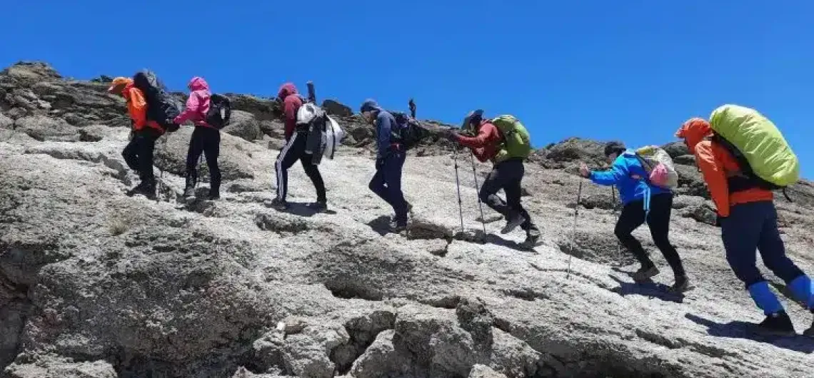
Mount Kilimanjaro’s total vertical elevation gain, with your sum ascent of all day-to-day segments to reach Uhuru Peak, standing at an official elevation of 5,895 meters (19,341 feet) above sea level, can vary from route to route and the number of days for your hike. Reaching the summit is a non-technical trek, but the elevation gain you experience is one of the biggest physical and physiological challenges. Unlike mountains with a single straight ascent, Kilimanjaro’s routes involve gradual climbs through five distinct ecological zones, with built-in acclimatization days that include some descent and re-ascent.“Elevation gain” has two important meanings on Kilimanjaro:
- Net elevation gain: The difference between your starting gate and the summit (typically 3,500–4,300 meters / 11,500–14,100 feet depending on the route).
- Total cumulative ascent: The actual uphill distance you hike, which is higher because of valleys, ridges, and acclimatization hikes (often 4,500–5,200 meters / 14,800–17,000 feet total).
The extra ascent from undulations is what makes longer routes like Lemosho excellent for acclimatization — you “climb high, sleep low.”
Elevation Gain by Popular Route
 Here is a factual comparison based on data gathered by Tranquil Kilimanjaro guides and GPS-tracked itineraries (figures are approximate and can vary slightly by exact trailhead and side hikes):
| Route | Starting Elevation | Net Gain to Summit | Approx. Total Ascent | Typical Duration | Success Rate (8+ days) |
|---|---|---|---|---|---|
| Lemosho | 2,100–2,360 m (6,890–7,743 ft) | ~3,535–3,795 m (11,600–12,450 ft) | 4,800–5,000 m (15,700–16,400 ft) | 7–8 days | 90–95% |
| Machame | 1,640–1,800 m (5,380–5,906 ft) | ~4,095–4,255 m (13,400–14,000 ft) | ~4,800–5,200 m | 6–7 days | 85–90% |
| Marangu | 1,843–1,879 m (6,047–6,164 ft) | ~4,016–4,052 m (13,176–13,384 ft) | ~4,300 m | 5–6 days | 65–70% |
| Rongai | 1,950–2,364 m (6,398–7,756 ft) | ~3,531–3,945 m (11,585–12,900 ft) | ~4,200 m | 6–7 days | 85% |
| Umbwe | 1,800 m (5,906 ft) | ~4,095 m (13,435 ft) | ~4,500 m | 5–6 days | Lower |
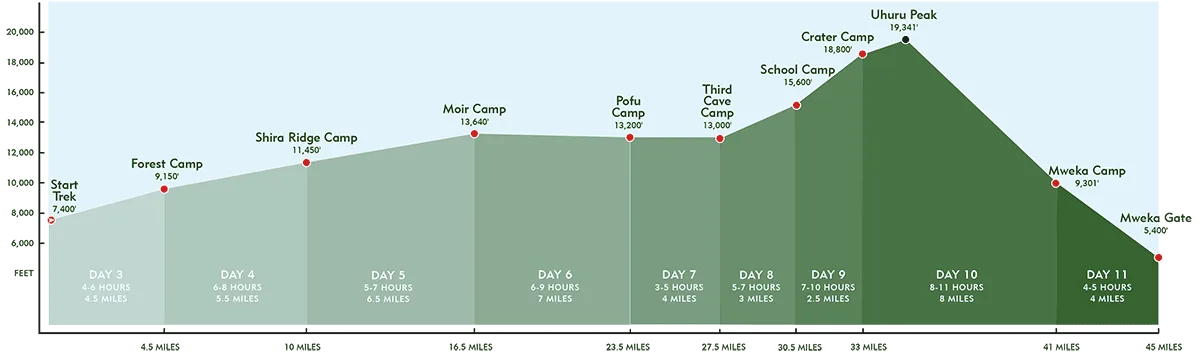
Lemosho Route Elevation Profile (8-Day Standard)
The Lemosho Route (the one most frequently recommended by operators like Tranquil Kilimanjaro) is prized for its scenic western approach and excellent acclimatization.
Here is the typical daily elevation profile:
- Day 1: Londorossi/Lemosho Gate → Mti Mkubwa (Big Tree Camp)
Gain: ~500–750 m | Distance: ~6 km | Time: 3–4 hrs - Day 2: Mti Mkubwa → Shira 1
Gain: ~600–700 m | Distance: ~8 km | Time: 5–6 hrs - Day 3: Shira 1 → Moir Hut
Gain: ~695–800 m | Distance: ~11 km | Time: 5–7 hrs - Day 4: Moir Hut → Barranco (via Lava Tower)
High point ~4,630 m, then descent to ~3,976 m (net loss but important acclimatization) - Day 5: Barranco → Karanga
Minimal net gain (~20 m) with ridge walking - Day 6: Karanga → Barafu
Gain: ~650–700 m - Day 7 (Summit Day): Barafu (~4,673 m) → Uhuru Peak (5,895 m) → Mweka Camp
Summit gain: ~1,200–1,222 m ascent | Total day: 12–14 hrs, ~17 km, with massive descent afterward - Day 8: Mweka Camp → Mweka Gate (descent only)
Overall for Lemosho 8 days: ~70 km total distance, total ascent approximately 4,800–5,000 meters.
Why Elevation Gain Matters on Kilimanjaro
- Altitude Sickness Risk: Symptoms of Acute Mountain Sickness (AMS) can begin above 2,500 m. Gradual routes like Lemosho give your body time to acclimatize.
- Pacing: The mantra is pole pole (“slowly slowly”). Most climbers ascend at 300–500 vertical meters per hour on the upper slopes.
- Summit Night: The final push from Barafu or Kosovo Camp involves the biggest single-day gain (~1,200 m) in darkness and freezing temperatures — the section where fitness and acclimatization are tested most.
- Descent: You lose nearly as much elevation on the way down as you gain going up, which is why knees and trekking poles become essential.
Machame Route Elevation Gain
(7-Day Standard Itinerary – Most Popular Version)
The Machame Route (often called the “Whiskey Route”) is scenic, challenging, and one of the most popular routes on Kilimanjaro. It starts at Machame Gate on the southwestern side and features dramatic ridges, the Barranco Wall, and excellent views. It has more undulations than Lemosho, which provides good (but not the best) acclimatization.
Core Statistics
- Starting Point: Machame Gate – 1,640–1,830 m (5,380–6,000 ft)
- Summit: Uhuru Peak – 5,895 m (19,341 ft)
- Net Elevation Gain: ~4,095–4,255 m (13,436–13,960 ft)
- Total Cumulative Ascent: ~4,800–5,200 m (15,750–17,060 ft)
- Total Distance: ~62 km (37–39 miles)
- Typical Duration: 6–7 days (7 days strongly recommended)
- Summit Success Rate: 85–90% on the 7-day itinerary
7-Day Machame Elevation Profile
| Day | From → To | Distance | Hiking Time | Elevation Change |
|---|---|---|---|---|
| 1 | Machame Gate → Machame Camp | 11 km (7 mi) | 5–7 hrs | 1,640–1,830 m → 2,850–3,000 m (+1,100–1,340 m) |
| 2 | Machame Camp → Shira Camp | 5 km (3 mi) | 4–6 hrs | 3,000 m → 3,810 m (+810 m) |
| 3 | Shira Camp → Lava Tower → Barranco Camp | 10–11 km (6–7 mi) | 6–8 hrs | 3,810 m → 4,630 m (high point) → 3,976 m (+820 m ascent / net descent) |
| 4 | Barranco Camp → Karanga Camp | 5 km (3 mi) | 4–5 hrs | 3,976 m → 3,995 m (+19 m net; steep Barranco Wall climb) |
| 5 | Karanga Camp → Barafu Camp | 4 km (2.5 mi) | 4–5 hrs | 3,995 m → 4,673 m (+678 m) |
| 6 | Barafu Camp → Uhuru Peak → Mweka Camp | 16–17 km (10 mi) | 12–14 hrs | 4,673 m → 5,895 m (+1,222 m) then descent to ~3,100 m |
| 7 | Mweka Camp → Mweka Gate | 10 km (6 mi) | 3–4 hrs | 3,100 m → 1,640 m (descent only) |
Key Feature: The route has significant “climb high, sleep low” opportunities (especially Day 3 via Lava Tower), but the daily gains are steeper than Lemosho in the middle section.
Marangu Route Elevation Gain
(6-Day Itinerary with Acclimatization Day – “Coca-Cola Route”)
The Marangu Route is the oldest and only hut-based route on Kilimanjaro (no camping). It follows a direct northeastern path and is often chosen by beginners because of the huts and shorter overall distance. However, it has fewer acclimatization opportunities and steeper daily elevation jumps, leading to a noticeably lower success rate.
Core Statistics
- Starting Point: Marangu Gate – 1,843 m (6,046 ft)
- Summit: Uhuru Peak – 5,895 m (19,341 ft)
- Net Elevation Gain: ~4,052 m (13,284 ft)
- Total Cumulative Ascent: ~4,300–4,500 m (14,100–14,760 ft) including acclimatization hike
- Total Distance: ~52–55 km (32–34 miles)
- Typical Duration: 5–6 days (6 days with an acclimatization day recommended)
- Summit Success Rate: 65–70% (lowest of the major routes)
6-Day Marangu Elevation Profile
| Day | From → To | Distance | Hiking Time | Elevation Change |
|---|---|---|---|---|
| 1 | Marangu Gate → Mandara Huts | 8 km (5 mi) | 4–5 hrs | 1,843 m → 2,700 m (+857 m) |
| 2 | Mandara Huts → Horombo Huts | 12 km (7.5 mi) | 6–8 hrs | 2,700 m → 3,720 m (+1,020 m) |
| 3 | Horombo Huts (acclimatization) | 5–6 km round trip | 2–3 hrs | 3,720 m → ~4,390 m Mawenzi Ridge (+670 m) then back to Horombo |
| 4 | Horombo Huts → Kibo Huts | 10 km (6 mi) | 6–8 hrs | 3,720 m → 4,720–4,750 m (+1,000–1,030 m) |
| 5 | Kibo Huts → Uhuru Peak → Horombo Huts | 12+ km round | 12–14 hrs | 4,720 m → 5,895 m (+1,175 m) then descent to 3,720 m |
| 6 | Horombo Huts → Marangu Gate | 18–20 km (11–12 mi) | 5–7 hrs | 3,720 m → 1,843 m (descent only) |
Key Feature: Large daily elevation jumps (often 1,000 m+) with limited “sleep low” opportunities. The optional acclimatization day at Horombo helps, but is still less effective than the gradual profile of Lemosho or Machame.
Quick Comparison
- Machame: More scenic, better acclimatization than Marangu, moderate-steep gains, higher success rate.
- Marangu: Shortest distance, hut comfort, but steepest daily ascents and lowest success rate among major routes.
Both routes reach the same summit, but longer, more gradual routes like Lemosho (as covered previously) generally offer the best chance of success because of superior acclimatization. Pole pole remains the golden rule — steady pacing is far more important than raw elevation numbers!
- Lemosho vs Marangu Route comparing the newer and the older routes on Kilimanjaro
- Lemosho or Northern Circuit Route, which is the best route to choose when trekking Kilimanjaro?
- Lemosho or Machame, which Kilimanjaro Route is Best for climbing Kilimanjaro?
- How many days are the Rongai, Machame, Lemosho, and Marangu routes?
- What is the success rate for the Rongai, Machame, Lemosho, and Marangu routes?
No matter which route you choose, the total elevation you actually climb is significantly more than the net height of the mountain itself. The extra meters from ridges, valleys, and acclimatization hikes are what separate successful summits from those turned back by altitude. If you’re preparing for Kilimanjaro (especially the Lemosho Route), understanding this profile helps you train smart — focus on long hikes with elevation rather than flat mileage. The mountain rewards steady, consistent effort over speed.
![]()