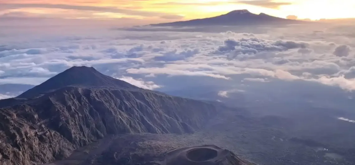
Mount Meru (4,562–4,566 m) and Mount Kilimanjaro (5,895 m) are two separate stratovolcanoes located about 70 km (43 miles) apart in northern Tanzania, even though they are part of the Eastern Arc ranges. The terrain between them consists mostly of savanna plains and lower ground rather than a continuous mountain ridge. There is no traditional mountain pass or col connecting them, as you would find in a mountain range.
I based this analysis on SRTM elevation data from CGIAR. I started by creating a map of the region around Mount Meru, Kilimanjaro, and Mount Kenya, using two colours:
- Green = 1,395 m or lower
- Purple = higher than 1,395 m
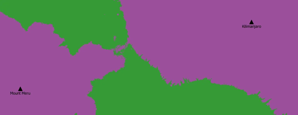
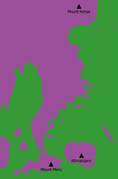 This map shows that you can travel from Mount Meru to Mount Kenya while staying entirely in the purple (higher) areas. However, to reach Kilimanjaro from Meru, you must cross green (lower) terrain. The narrow purple connection just north of Mount Meru corresponds to the key col linking Meru to Mount Kenya at 1,395 m. To answer your specific question — what is the highest possible saddle between Meru and Kilimanjaro — I adjusted the elevation cutoff through trial and error until I found the lowest value that still allowed a continuous high-ground (purple) connection between the two mountains. At a cutoff of 1,373 m (green = 1,373 m or lower, purple = higher than 1,373 m), a path finally appears connecting Mount Meru to Kilimanjaro while staying in purple terrain. This represents the highest saddle between the two peaks.
The col between Mount Meru and Mount Kilimanjaro is approximately 1,373 metres above sea level (give or take a few metres). This is roughly 20 metres lower than the key col between Mount Meru and Mount Kenya. The approximate location of this col is around 37.0050°E, 3.1382°S. Because the terrain in that area is quite flat, the exact spot would be difficult to identify if you were standing on the ground.
 Topographic Context (Prominence & Key Col)
 Topographic Context (Prominence & Key Col)
The question often comes up in the context of topographic prominence (how independent a peak is). Here’s the precise answer:
- Mount Meru has a prominence of approximately 3,170 m.
- Its key col (the saddle used to calculate prominence) sits at roughly 1,395 m elevation.
- Surprisingly, Meru’s parent peak (the higher mountain it is connected to via its key col) is Mount Kenya, not Kilimanjaro — even though Kilimanjaro is much closer and taller.
Why not Kilimanjaro?
Because the highest continuous high ground (ridge/contour) connecting Meru to a taller peak leads northwest toward Mount Kenya. The saddle you would have to cross to link Meru directly to Kilimanjaro while staying on relatively high terrain is slightly lower—around 1,373 m.In simple terms:
To travel from Meru to Kilimanjaro while avoiding dropping below ~1,373–1,395 m, you still have to descend into lower ground between the two mountains. The slightly higher connection goes the other way, toward Kenya.
Local Feature on Mount Meru Itself
On Mount Meru, there is a well-known saddle called the Meru Saddle (or simply “the Saddle”). This is where Saddle Hut (≈ 3,500–3,570 m) is located, between the main summit of Meru and the subsidiary peak Little Meru. This is a completely different feature, not one between Meru and Kilimanjaro.
- Where is Mount Kenya Located?
- Where is the Ol Doinyo Lengai mountain located?
- Where is Mount Meru located? Tanzania’s second highest mountain and Africa’s 5th tallest.
Summary
| Feature | Location | Elevation | Notes |
|---|---|---|---|
| Key col (prominence) | Between Meru & its parent terrain | ~1,395 m | Connects to Mount Kenya |
| Col to Kilimanjaro | Between Meru & Kilimanjaro | ~1,373 m | Slightly lower; no named pass |
| Meru Saddle (local) | On Mount Meru itself | ~3,550 m | Where Saddle Hut is located |
| Actual ground between peaks | Plains between the two mountains | Much lower | Savanna/lowland area |
There is no famous or named “col” (mountain pass or saddle) directly between Mount Meru and Mount Kilimanjaro
There is no significant or named col/pass between the two mountains. The ~1,373–1,395 m figure is purely a topographic measurement used for prominence calculations and doesn’t correspond to any actual hiking route or landmark you would encounter when climbing either mountain.
The col between Mount Meru and Mount Kilimanjaro is approximately 1,373 metres above sea level (give or take a few metres). This is roughly 20 metres lower than the key col between Mount Meru and Mount Kenya. The approximate location of this col is around 37.0050°E, 3.1382°S. Because the terrain in that area is quite flat, the exact spot would be difficult to identify if you were standing on the ground.
What is the height of Mount Kilimanjaro and how high is its highest point in meters or feet?
Would you like a topographic explanation with a map reference, or details on why climbers often do Meru before Kilimanjaro for acclimatization?
More about Mount Meru and Kilimanjaro
- Mount Meru Hotel: Luxury Hotel in Arusha
- Mount Meru Group Joining Treks
- Mount Meru crew: mountain guides, porters, cooks, and an armed ranger
- Why do you need an armed ranger to climb Mount Meru
- Mount Meru, Kilimanjaro’s little brother
- 16 Days Mount Meru, Kilimanjaro, Safari, and Zanzibar Beach
- Breakfast on Mount Kilimanjaro, Mount Kenya, Mount Meru, Rwenzori, Ol Doinyo Lengai
- Mount Kenya & Mount Kilimanjaro, 2 Weeks & 2 peaks
- Mount Kenya, Mount Meru & Mount Kilimanjaro (3 Peaks – 3 Weeks)
- 3 Peaks, 30 Days Grand East Africa Trek & Rwenzori (Uganda), Mount Kenya, Kilimanjaro (Tanzania)
![]()