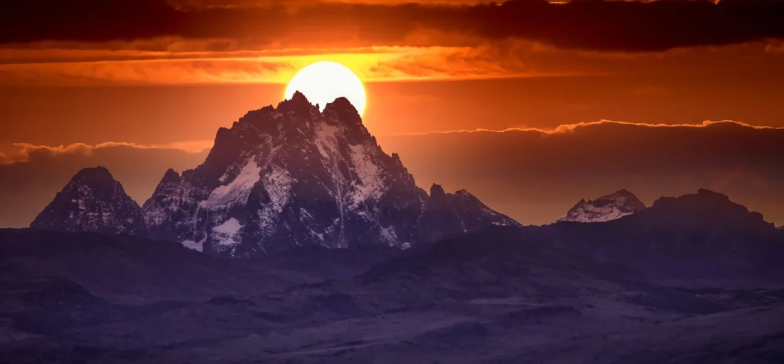
Mount Kenya is a large and remarkably symmetrical volcanic cone with an average diameter of 120 kilometres at its base. The formation of Mount Kenya, Kenya’s highest mountain began between 2.6 and 3.1 million years ago as a result of successive eruptions of lava and agglomerates from a central vent in the Earth’s surface. This continuous volcanic activity led to the gradual buildup of layers, forming the distinctive cone-shaped structure of Mount Kenya that we see today.
The lava, resulting from a rapid outflow of liquid rock, formed the base of the cone, while the agglomerates were composed of a mixture of coarse and fine particles. These agglomerates were formed during explosive eruptions, where shattered fragments of rock were forcefully expelled from the central vent and then settled on the slopes of the cone. Over time, these particles consolidated into solid rock. A prime example of this type of geological formation can be observed along the trail of the Chogoria route. The original height of Mt. Kenya was estimated to be 7,000 feet, and it even possessed a summit crater similar to the Kibo cone of Kilimanjaro. However, due to the erosion caused by glaciers, approximately 2000 feet of the volcano’s upper portion has been worn away. As a result, the mountain now showcases a rugged glacial topography, characterized by various relief features.
- .Aretes-Knife edged ridges
- U- shaped valleys
- Rock basins some filled up with glacial lakes called tarns,
The lower slopes of the cone display numerous streams that have carved steep-sided valleys, creating a distinct radial drainage pattern. On the north and northwestern side of the mountain, all the streams converge into the Ewaso Ngiro River, while the remaining streams flow into the Tana River, ultimately reaching the Indian Ocean. The highest peaks, Nelion and Batian, are located on the neck or plug of the volcanic rock that cooled gradually beneath the surface during the volcano’s eruption. These peaks are primarily composed of a granular intrusive igneous rock called “Nepheline” or “Keynite,” which falls under the hyper-byssal classification.
Now let’s check out the following technical-sounding terms.
• Igneous-Formed through a heating process pompous
• Intrusive -the magma cooed and solidified below the surface.
• Hyper-byssal– refers to the relative shallowness of the depth under which it cooled.
This particular rock exhibits a range of colors, including pale grey, grey-brown, and red. It is often characterized by the presence of large white feldspar crystals and smaller nepheline crystals. As we descend to the lower portion of the cone, we encounter various types of lava and agglomerates. Many of these rocks contain weathered feldspar crystals that can be easily observed scattered across the ground. The central vent of the volcano ceased activity approximately 2 million years ago; however, the side or satellite cones on the east and north eastern slopes remained active. Notable examples of these satellite cones include the “Giant billiard table,” “Mugi” Hill, and “Ithangune” hill, which are visible along the ascent from Harris tarn to Lenana. On the eastern side, about 60km away, we find the “Nyambene” range, a series of basalt cinder cones that formed a mere 100,000 years ago. During a period of significantly cooler global climates, when large ice-sheets covered extensive areas of northern Europe and Canada, the glaciers on Mt. Kenya likely extended as low as 3000m in elevation. These glaciers were responsible for shaping the deep U-shaped valleys that can be observed on the slopes of the cone. Within these valleys, we find different types of moraines, such as lateral, medial, and terminal ridges or lines of boulders and gravel. These moraines represent the eroded materials carried by and under the glaciers. The elevation of these moraines provides valuable evidence of the glaciers’ past extent. Unfortunately, little is currently known about the specific glaciation episodes and the stages of glacier retreat. However, it is believed that the glaciers reached their largest size approximately 18,000 years ago during the last glacial maximum. They may have experienced a re-advance around 170 years ago during a period known as the little ice-age. Since then, the glaciers have been rapidly retreating. In 1893, Geologist J.W. Gregory initiated the scientific documentation of Mt. Kenya’s glaciers. Since then, continuous monitoring and recording have been conducted by S. Hastenrath and R. Caudwell. Their research indicates that the glaciers are retreating at an increasingly accelerated rate, with both the snouts and overall volume decreasing. If this rate continues, it is estimated that our beloved mountain will eventually lose all of its permanent ice. As evidence, since Gregory’s initial recording, 8 out of the 18 glaciers that were documented have already disappeared.
The Geological processes that led to the formation of Mount Kenya
The formation of Mount Kenya involved several geological processes spanning millions of years:
- Volcanic Activity: Mount Kenya began forming around 3 million years ago during the Pliocene epoch through volcanic activity. Lava and volcanic ash erupted from the Earth’s crust, accumulating in layers over time.
- Accumulation of Material: The layers of lava and volcanic ash gradually built up, contributing to the growth of the mountain’s mass. This accumulation process continued as volcanic eruptions deposited more material.
- Tectonic Uplift: The movement of tectonic plates, particularly the African Plate, led to the uplift of the landmass that would eventually become Mount Kenya. This upward movement contributed to the elevation of the mountain.
- Erosion: As Mount Kenya rose, natural forces such as glaciers, rivers, and weathering processes began to shape its surface. Glaciers carved out valleys and ridges, while rivers eroded the landscape, contributing to the mountain’s distinctive features.
- Geological Time: These processes occurred over millions of years, gradually shaping Mount Kenya into the mountain we see today. The ongoing interaction of volcanic activity, tectonic movement, and erosion continues to influence the mountain’s landscape.
Related: How was Mount Kilimanjaro formed?
![]()