Worried about Mount Kilimanjaro erupting while you climb? The good news is it is not happening any soon and it should be the least of your worries. The last significant eruption occurred 360,000 years ago, and the most recent activity was roughly 150,000 – 200,000 years ago. Mawenzi, Shira, and Kibo are the three volcanic cones found on Kilimanjaro. The tallest mountain, Kibo, remains dormant and has the potential to erupt again, while Mawenzi and Shira are extinct.
Around 50 of the estimated 1,500 active volcanoes will erupt each year, releasing harmful gases, ash, steam, and lava onto the surrounding area. Any nearby people, animals, or plant life suffers greatly as a result of this horrific incident. In the past 200 years, volcanic eruptions are thought to have directly caused the deaths of roughly 250,000 individuals.
It is reasonable to inquire about the possibility of Kilimanjaro erupting if you want to climb it.
Although it may be chilly now, Uhuru Peak wasn’t always this way. Although none of the three dormant volcanoes that make up Kilimanjaro have erupted recently, the mountain’s explosive past isn’t as distant as you may imagine!
Kilimanjaro began to rise around 750,000 years ago as a result of thousands of years of lava eruptions from the volcanic cones Shira, Mawenzi, and Kibo, which are located close to the fault line of two tectonic plates. The three cones eventually faded out one by one, with Shira being the first to collapse after reaching a height of almost 16,400.
Before Mawenzi went out at a height of around 18,000 feet, Kibo and Mawenzi continued to erupt, generating the ridge now known as “the saddle.” It’s possible that Kibo reached even higher elevations back then; since Kilimanjaro stopped erupting, the biggest change in its height has come from erosion by the elements. Kibo continued to erupt until somewhere between 150,000 and 200,000 years ago, at which point it had reached the 19,341 foot elevation we know today.
Kilimanjaro wasn’t going to become a calm middle-aged mountain just because the summits had stopped growing on their own.
Even though there haven’t been any significant eruptions for a very long time, molten lava is still flowing only 400 meters beneath the top, according to research from 2003 on fumaroles close to Kibo’s peak.
Kili may eventually erupt (or collapse), although no volcanic activity is anticipated from Kili in the near future, according to experts. Trekkers need not be concerned unless they are afraid of the sulfurous odours at the summit.
When did Mount Kilimanjaro last erupt?
Kibo’s most recent significant eruption took place 360,000 years ago. But 200,000 years ago was when it last engaged in action. The mountain’s highest peak is 19,340 feet above sea level.
But according to experts, the peak may have been considerably higher before the effects of natural weathering and erosion were taken into account.
One day Mount Kilimanjaro could erupt once more or perhaps succumb to its own weight. However, there are currently no indications that the mountain would erupt in a spectacular volcanic display in the near future, according to geologists.
Will Mount Kilimanjaro ever erupt again?
Let’s start by talking about how the mountain was created. It took Mount Kilimanjaro 750,000 years to create. It started when hot, molten rock known as magma from the Earth reached the surface. The volcano erupted because the pressure on a magma chamber drove magma up through the vents.
As the lava kept flowing, the mountain became bigger and bigger over time.
Shira, Mawenzi, and Kibo are the three volcanic cones that make up Mount Kilimanjaro. Each is located close to the tectonic plate fault. The volcanic cones on Kilimanjaro ceased to exist after countless years of eruptions.
2.5 million years ago, the Shira went extinct. Prior to its collapse, the volcano was thought to have been between 16,000 and 17,000 feet tall, giving rise to the “Shira Plateau.”
One million years ago, Kibo and Mawenzi started to erupt, creating the ridge presently known as “the Saddle.” After reaching a height of almost 18,000 feet, Mawenzi eventually perished some 450,000 years ago.
The tallest mountain, Kibo, is dormant while the volcanoes Mawenzi and Shira are extinct. Or put another way, Kibo may explode once more.
Although there haven’t been any significant eruptions recently, the activity in the mountain chambers is still visible. Sulfurous gases are released by fumaroles, most notably from Crater Camp and the ash pit. According to research published in 2003, molten lava is still gushing 400 meters under Kilimanjaro’s peak.
Kilimanjaro’s last volcanic activity
Kilimanjaro’s volcanic interior is little understood since there hasn’t been much erosion to reveal the igneous layers that make up the volcano’s structure.
The Shira center began erupting some 2.5 million years ago, and the final significant episode happened right before the northern section of the structure collapsed, at around 1.9 million years ago.
At 3,800 meters (12,500 feet), Shira is capped by a large plateau that may be a filled caldera. The remaining caldera rim has suffered significant erosion damage. Shira could have been between 4,900 and 5,200 m (16,100 and 17,100 ft) high before the caldera formed and erosion started. With some pyroclastics, it is largely made of basic lavas.
Although lava erupted from ring cracks as the caldera formed, there was no significant explosive activity. Later, the doleritic Platzkegel in the caldera’s center and the phonolitic cone at the ridge’s northwest end developed.
A million years ago, Mawenzi and Kibo both first started to erupt. The Saddle Plateau, which is located at an elevation of 4,400 meters (14,400 feet), divides them. 3
The oldest rocks in Mawenzi are 448,000 years old on average. With pinnacles and ridges expanding to the northeast, Mawenzi creates a horseshoe-shaped ridge. Its tower-like appearance is the product of extensive erosion and a mafic dike swarm. The ring was sliced through by many substantial cirques. On top of the Great Barranco gorge is the greatest of them.
On the northeastern side of the mountain, the East and West Barrancos are also noteworthy. Erosion has eroded the majority of the mountain’s eastern side. Neumann Tower, a subsidiary peak of Mawenzi, is 4,425 meters high (14,518 ft).
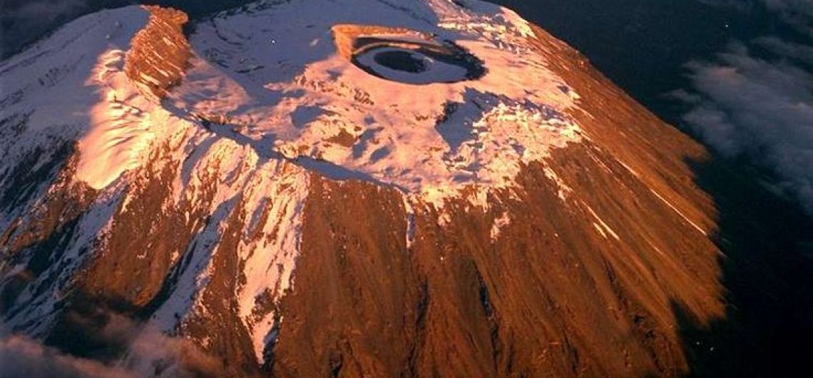
At the Saddle Plateau height, Kibo, the mountain’s greatest cone, is more than 24 km (15 km) broad. The present-day Kibo summit crater was formed here between 150,000 and 200,000 years ago during the last activity. Kibo’s crater still has gas-emitting fumaroles. With escarpments reaching 180 to 200 metres (590 to 660 feet) on the south side, Kibo is topped with a nearly symmetrical cone. These escarpments outline a crater that is 2.5 kilometers (1.6 miles) wide and was created when the peak collapsed.
The Tanganyika government named the Inner Cone’s crater the Reusch Crater in 1954 after Gustav Otto Richard Reusch after he scaled the mountain for the 25th time. The Inner Cone is located within this caldera (out of 65 attempts during his lifetime). The Ash Pit is located inside the Reusch Crater and is 350 meters (1,150 feet) deep. The Western Breach and the Great Barranco were created when a portion of Kibo’s crater rim fell some 100,000 years ago.
Most earlier geological features are covered by a fairly continuous layer of lava, with the exception of exposed layers in the Great West Notch and the Kibo Barranco. The former reveals syenite intrusions. There are five major lavas on Kibo:
- Phonotephrites and tephriphonolites: On a dyke cropping out at 4,600 meters (15,100 feet), phonotephrites and tephriphonolites of the Lava Tower group were found that date to 482,000 years old.
- Tephriphonolite to phonolite lavas of the Rhomb Porphyry group, dated to 460,000–360,000 years old, are “marked by rhomb mega-phenocrysts of sodic feldspars.”
- The Lent group’s aphyric phonolite lavas, which are dated to about 359,000 and 337,000 years ago, are “often underlain by basal obsidian horizons.”
- Porphyritic tephriphonolite to phonolite lavas: Lavas of the Caldera Rim group with porphyritic tephriphonolite to phonolite composition that date to 274,000–170,000 years ago
- Phonolite lava flows with aegirine phenocrysts: The Inner Crater group, which is composed of phonolite lava flows with aegirine phenocrysts, is Kibo’s most recent volcanic activity.
More than 250 parasitic cones, which were produced between 150,000 and 200,000 years ago and erupted picrobasalts, trachybasalts, ankaramites, and basanites, can be found on Kibo’s northwest and southeast slopes. They extend as far as the Lengurumani Plain in the northwest, Lake Chala, and Taveta in the southeast. With the exception of the Saddle Plateau cones, which were severely impacted by glacial activity, most of these cones remain in good condition. Large areas of the mountain have been hidden by the cones’ lava, despite their generally tiny size. While the Upper Rombo Zone cones mostly produced lava flows, the Saddle Plateau cones are primarily cinder cones with terminal effusions of lava. The Saddle Plateau’s cones are all glaciation-old.
Maasai accounts from the 19th century claim that a settlement on Kibo’s eastern side called Lake Chala was destroyed by an eruption.
So, if climbing Mount Kilimanjaro is on your bucket list, you need not be afraid. Near the top, you might catch a whiff of sulfur, but otherwise, the mountain is still peacefully asleep. And you ought to make an effort to follow suit.
How can we tell when a volcano will erupt?
The majority of volcanoes issue warnings prior to an eruption. The rising of magma toward the surface during magmatic eruptions typically results in audible earthquakes. Additionally, it can induce changes in the temperature and chemical of groundwater and spring fluids as well as alter the ground surface. However, steam-blast eruptions, which happen when superheated water flashes to steam, can happen suddenly or without much warning.
There may be notable signs before an eruption, such as:
- an increase in the number and power of earthquakes that may be felt
Significant steaming or fumarolic activity as well as new or extended hot ground regions - the surface of the earth somewhat swells
- slight variations in heat flow
- alterations in the relative abundances or composition of fumarolic gases
The kind or size of an anticipated eruption is not indicated by these precursors (that information is best obtained by mapping previous eruptions). Before eruptive activity starts, precursors might last for weeks, months, or even years. They can also end at any moment without being followed by an eruption. For example, over 60 years have passed since the Campi Flegrei volcano in Italy began to exhibit symptoms of disturbance.
How Do Volcanoes Erupt?
Because of how hot it is deep under the Earth, certain rocks slowly melt and turn into a thick, flowing material known as lava. Magma rises and gathers in magma chambers because it is lighter than the surrounding solid rock. A portion of the lava eventually rises to the Earth’s surface through vents and cracks. Lava is a term used to describe erupting magma. There are explosive volcanic explosions and there aren’t.
What are some benefits of volcanic eruptions?
Volcanic materials eventually deteriorate and weather to form some of the most fertile soils on Earth, whose cultivation has produced an abundance of food and supported civilizations. Over the course of geologic time, volcanic eruptions and related processes have benefited mankind both directly and indirectly. Geothermal energy is produced by using the internal heat associated with nascent volcanic systems.
Are there any active volcanoes in Tanzania?
Yes, Mount Ol Doinyo Lengai in Northern Tanzania is an active volcano that recently showed signs of volcanic activities in 2019. Below is. list ost of volcanoes in Tanzania, both active, dormant, and extinct.
| Name | Elevation | Location | Last eruption | |
|---|---|---|---|---|
| metres | feet | Coordinates | ||
| Burko | – | – | – | – |
| Embulbul | – | – | – | – |
| Elan Nairobi | – | – | – | – |
| Esimingor | – | – | – | – |
| Gelai | – | – | – | – |
| Igwisi Hills | – | – | 4.87°S 31.92°E | Holocene |
| Izumbwe-Mpoli | 1568 | 5144 | 8.93°S 33.40°E | Holocene |
| Ketumbaine | – | – | – | – |
| Kieyo | 2175 | 7136 | 9.23°S 33.78°E | 1800 |
| Mount Kilimanjaro | 5895 | 19,340 | 3.07°S 37.35°E | – |
| Lemagrut | – | – | – | – |
| Mount Loolmalasin | 3682 | – | – | – |
| Meru | 4565 | 14,977 | 3.25°S 36.75°E | 1910 |
| Ngorongoro | – | – | 3.15°S 39.30°E | – |
| Ngozi | 2622 | 8602 | 8.97°S 33.57°E | Holocene |
| Ol Doinyo Lengai | 2962 | 9718 | 2.764°S 35.914°E | 2017 |
| Oldeani | – | – | – | – |
| Olmoti | – | – | – | – |
| Olossirwa | – | – | – | – |
| Mount Rungwe | 2961 | 9714 | 9.13°S 33.67°E | Holocene |
| Unnamed | – | – | 8.63°S 33.57°E | Holocene |
| Usangu Basin | 2179 | 7149 | 8.75°S 33.80°E | Holocene |
![]()